Categories
East End Toronto Toronto Transit Urbanism

Choice REIT’s plan for Woodbine and Danforth needs to go back to the drawing board

The following is an as-brief-as-possible note on BA Group’s “urban transportation considerations” report, prepared for Choice Properties REIT and pertaining to the development proposal for 985 Woodbine Avenue. It’s dated dated February 27, 2019, and available as part of the supporting documentation at http://app.toronto.ca/DevelopmentApplications/associatedApplicationsList.do?action=init&folderRsn=4533699&isCofASearch=false&isTlabSearch=false

Some of the inaccuracies I point out are trivial, but there’s enough of them to convince me that the sloppiness with regard to basic facts is in keeping with the main impression I’ve received: that the report’s handling of the local transportation context, particularly regarding public transit, is lazy and dangerously superficial 

BASIC ERRORS OF FACT:

Page 1: That 985 Woodbine is “in the northeast quadrant of Woodbine Avenue / Danforth Avenue in the East York district of the City of Toronto.” Close but no cigar. Properties on the north side of Strathmore Blvd. are in old East York, but the site in question is in the old city of Toronto. 

Page 1: That the bus routes feeding Woodbine station are high-frequency routes. The TTC has 47 high-frequency service routes (10 minutes or better) and none of the three routes serving Woodbine makes the list. The error is repeated on Pages 6 and 28. Here’s the TTC link for reference: https://www.ttc.ca/News/2015/June/0615_10min-service.jsp 

Page 2: The proposed development would comprise retail uses and 402 residential units (rental). All the other source documentation indicates that only 14 of the 402 residential units will be rental.

Page 8: On point 15 under vehicle parking, the numbers don’t add up; the implication being that 300+40+60=360, rather than 400.

Page 15: The report says the posted speed limit on Woodbine is 50 km/h; there is no posted speed limit since the signs were removed when the street was modified for bike lanes in the fall of 2017.

Page 15: The report states that the posted speed limits for all four of Woodmount Ave., East Lynn Ave., Coleridge Ave., and Patricia Ave. are 40 km/h. In fact, they are all 30 km/h.

Page 16: A minor quibble, but it is Kennedy Road, not Kenney. And it’s tough to characterize the SRT as the “Scarborough Subway line.”

Page 17: The 92 Woodbine South bus operates at 12-minute headways, not 10.

Figure 3 map: Omits Amroth Ave., which is significant for this particular proposal in that Amroth is directly across Danforth from where the mid-block entrance to the development would be required under the official plan amendment that the developer is appealing. (The developer would actually benefit from the mid-block break and should let planners and architects trump the short-term concerns of Choice REIT’s accountants in this one.)

Figure 4 map: The claim that it’s a five-minute walk from Main Street station is at best exaggeration, but wrong for the vast majority of the population. I’ve walked it several times and, at my brisk pace and it comes in usually around 8.5 minutes. The TTC calls it 10 minutes and even has it as 10 minutes on its sign at Main Street station (see photo).

Page 28: The claim that 985 Woodbine is within 800 metres of the Danforth GO station is also wrong. It’s 1.1 kilometres, or about 900 as a crow flies. 

Page 29: Quibble, I know, but Aldridge Avenue is misspelled.

QUESTIONABLE CLAIMS:

Page 1 and repeated on Pages 6, 17 and 22 : “The site is very well served by higher order transit service.” This was once very much the case, and the subway service is usually quite good outside of the peak periods, especially if you don’t have to change trains at Bloor-Yonge or St. George stations. Alas, this is a neighbourhood filled with people who endured bidding wars or paid extra for a house close to the subway, only to realize there is often no room on the trains in the morning. Without a Relief Line in operation, large numbers of would-be transit users have given up on the Bloor-Danforth, almost certainly in large part because of crowding and reliability issues. According to the TTC’s station usage reports, a.m. peak-hour ridership from Woodbine is down 51.7% since the mid-1970s and 23.1% since the mid-1980s (the file is a massive PDF, but I can forward to individuals who want it). There is spare a.m.-peak capacity, but it’s on eastbound trains. Also, the fact that the Danforth GO station is an 8.5- to 10-minute walk from a subway station one stop to the east (with an extra fare required) is a largely irrelevant transit attribute. There’s very little connection between the TTC’s Main station and GO’s Danforth as is, and for people living a subway station further west there will be virtually none, especially in the a.m. peak when GO trains are jammed, too.

Page 1: Mid page there is a reference to 985 Woodbine being within a mixed-use area. Well, sort of. It used to be an area with a healthy mix of primary uses prior to de-industrialization after World War 2. Within the 800-metre extended pedestrian catchment area of the station, the mix ratio is overwhelmingly residential to jobs, 88:12, and most of the non-residential is secondary use, ie uses that don’t draw people from other parts of town or keep people from leaving the area in the a.m. peak. Unbalanced mixes of primary use make it harder for shops and restaurants to make it as they have to do too much of their business in more limited time periods (the area could use a lunchtime crowd).

Page 8: Point 13 under TDM (transit-demand management) … We’re told the plan “will encourage transit use”? What capacity? Which direction? What times of day? Will it really facilitate reduced car ownership and usage? While not every unit will have a parking spot, the number of spots is being increased considerably, from 149 to 264.

Page 13: Point 55 correctly states the site represents an opportunity for development with a high rate of transit usage, but that is probably not the case for   an overwhelmingly residential development. There is opportunity in the significant spare subway capacity in the a.m. rush, but it’s on the eastbound trains, outbound from the core. If this is to be a development that seizes the opportunity, it would be one with significant levels of employment or, office or institutional maybe, or possibly an education facility. And regular daily visitors to the neighbourhood for daytime hours is what the local economy needs, too. 

Page 17: The various TTC surface routes mentioned are serving as feeders to a subway system with peak-hour capacity troubles. They’re of little relevance to the site unless it becomes a destination for uses other than residential. The GO lines mentioned are not going to be much of an attraction as Danforth GO is not easily accessed (despite claims in this report) and because TTC transfers are no good on GO, even for trips that begin and end in Toronto.

Page 21: Car share is touted as a useful service, rightfully, but if it is so good, why the 33% reduction in the number of car-share spots from the current nine.

Page 23: The claim that the development “will serve to reduce the traffic related impact,” is a stretch. It might not increase the traffic-related impact.

Page 24: The references to planned transit improvements overstate the potential. GO Regional Express Rail (rebranded by the new provincial government as GO Expansion) and SmartTrack might be an attraction to people living within a couple of 100 metres of Danforth station, but it largely missed an opportunity to alleviate transit crowding in east Toronto by ignoring the potential of a station at Coxwell (which scanned better than most of the approved RER and SmartTrack stations). The downtown relief line is crucial to addressing the overloaded subway system, but as many in the area like to point out, it doesn’t come far enough east. All the “To” stations east of Pape, excluding the terminal at Kennedy, have been steadily losing ridership in recent decades, almost certainly because of crowding, and the situation is likely to get worse when the Bloor-Danforth line is extended deeper into Scarborough. And the reference to help from the Eglinton Crosstown makes no sense, at least until the Relief Line (or Ontario Line) gets to Eglinton.

Page 27: The transportation-demand-management argument as presented here ignores the elephant in the room: This site is served by a subway line that has huge spare capacity in the a.m. peak period, but it’s all on the eastbound trains. If the developer and its advisers were serious about the stated goal to “Encourage the use of alternate travel modes (transit, cycling and walking), it would be focusing its residential offerings to seniors or downsizing retired boomers, or putting up office buildings on the site. Without adequate transit-capacity supply inbound in the a.m. peak, we probably don’t want more people at Woodbine and Danforth on the origin end of the trip pairings. And, if there’s not enough of a market for office space at this location from the private sector, the public sector could be helping by relocating workers from costly market office spaces where leases are expiring. The other goals listed — increasing vehicle occupancy, shifting to off-peak periods and reducing VKT — are all good, but likely to be of little help. (Nearly all of the subway’s ridership growth in recent decades has been off-peak because the system is capacity constrained to the point of unreliability and general unpleasantness in the rush hours).

Page 27: Under organizational framework, “Enhance Pedestrian Access and Walkability” … again a fine goal, but the developer and its advisers are fighting a requirement that the long block from Woodbine to Cedarvale be broken up. It might not be the most egregious case of a pedestrian-unfriendly block length in the general area, but it’s still as much as twice as long as the lengths recommended by Jane Jacobs, Jan Gehl and the Smart Growth Network’s Reid Ewing. 

Page 28: Again we get reference to “mixed use,” without an apparent realization that it’s the primary-mixed use that the neighbourhood needs, and which the infrastructure can support. Grocery and other retail stores will be almost exclusively secondary-mixed uses, a segment that always underperforms in the absence of a rich primary mix.

Page 28: Aside from the aforementioned erroneous claims under transit use, it seems the advice being given the developer is to add to the crowding in the overused transit flows and ignore the opportunity in the underutilized services. 

The flawed thesis:

The repeated assertions that the generally low use of transit within the neighbourhood “largely reflect the prevalence of low-rise, single family dwellings” seem to overlook the fact that this is a fairly dense neighbourhood, with lots of people who moved here hoping to use the subway, before deciding it’s too crowded.

At 18,291 people and jobs within the 800-metre radius that Metrolinx uses for its standard station-catchment zones, this area is already 83% more dense than Metrolinx’s 2031 goal of 10,000 for its Mobility Hubs. It’s already denser than two-thirds of the current mobility hubs. The area probably can take considerably more residential density — once a relief line/Ontario Line is open as far as Eglinton and once better connections to GO and SmartTrack are in place. But even then, with a serious shortage of sites near the subway stations that can accommodate office uses to help address the neighbourhood’s badly unbalanced mix of primary uses, it would seem both local residents and the city as a whole have strong reasons to be pushing for a better mix of uses on the 985 Woodbine site. The argument that people are driving to work from the Woodbine-Danforth neighbourhood because they might have the ability to park a car at their homes is far less compelling than the one that they’ve fled transit because of crowding.

A quick suggestion:

Page 28: The idea of a pre-loaded Presto card is a good one, but maybe condo buyers might want the choice of a credit worked out with a local bike shop instead.

Categories
East End Toronto Toronto Transit Uncategorized Urbanism

Has the SmartTrack plan left the station at Coxwell?

An earlier version of this post erroneously said Coxwell-Monarch Park was cut from consideration when the list of stations for consideration went from 120+ to 50+: Mea culpa. C-MP was not cut until the next phase, but it nevertheless was deemed unworthy of an initial business case, which remains unthinkable (and some at Metrolinx quietly agree, even if that’s an uncomfortable position for their bosses).

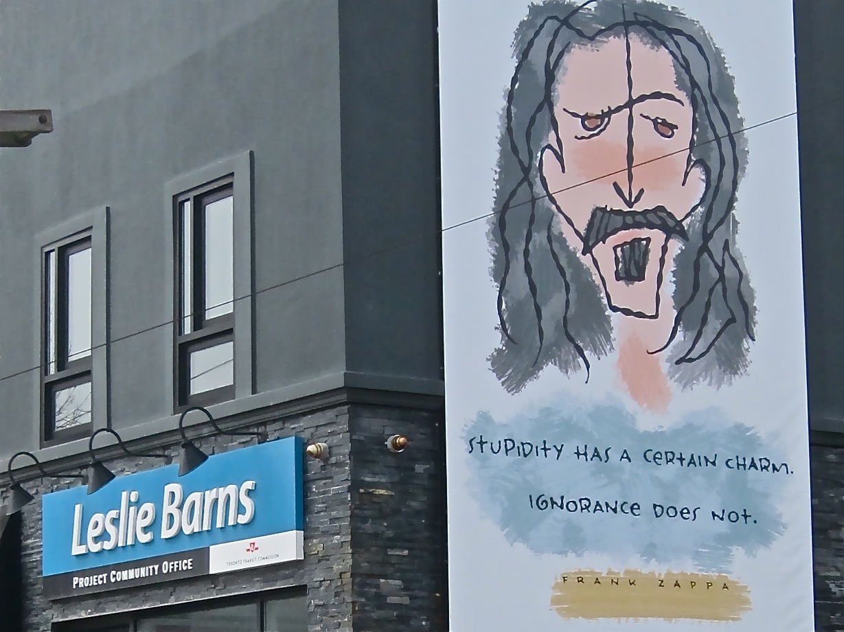
The following post illustrates potential flaws in the SmartTrack and Regional Express Rail planning and assessment process by looking at the case of an almost certainly vital station site that appears to have been overlooked altogether. This note was prepared as feedback for the public consultation process and was submitted In August 2018. Today, Sept. 25, 2018, I received by email a form letter from the office of Environment Minister Rod Phillips dated Sept. 19, basically saying my concerns are frivolous. Judge for yourself. Anybody interested in seeing the PDF files of the 2014 TTC report, the Ministry’s “Confidential” SuperGO report from the 1970s or the Environment Minister’s letter should contact me by email at stephen.j.wickens@gmail.com. 

I’ve held off posting this until now to give the province an opportunity to reply. The main point is that our process for evaluating and planning transit infrastructure is broken and that this should be a major concern for all levels of government, especially a new government that has promised to change things. The decision not to seriously tackle our transportation problems has had, and will continue have, a massively negative effect on Ontario and the Toronto’s area’s competitiveness and livability, while undermining the confidence of people in our democratic processes. 


August 20, 2018

Feedback including objections regarding negative impacts of the current station plan for SmartTrack:

Submitted to:

– Jade Hoskins Senior Public Consultation Co-ordinator, City of Toronto (SmartTrack@toronto.ca)

– Georgina Collymore, Senior Adviser, Communications and Stakeholder Relations at Metrolinx (newstations@metrolinx.com)

Cindy Batista (Special Project Officer, Ministry of the Environment, Conservation and Parks (Environmental Assessment and Permissions Branch) (cindy.batista@ontario.ca)

From Stephen Wickens, East-end Toronto resident and semi-retired journalist with a lifelong interest in transportation and commercial real estate matters. (stephen.j.wickens@gmail.com)


Thirty spokes are made one by holes in a hub,

by vacancies joining them for a wheel’s use.

The use of clay in moulding pitchers

comes from the hollow of the pitchers’ absence.

Doors and windows in a house

are used for their emptiness.

Thus we are helped by what is not

to use what is. 

– Laotze


A little background: As I’ve written on a few occasions (in newspaper columns, in email and face-to-face discussions with private- and public-sector transportation professionals and on social media), there is the germ of a very good idea in the SmartTrack (ST) plan and much opportunity in how it can piggyback onto Metrolinx’s Regional Express Rail (RER) initiative. But for reasons that appear to include political intransigence and interference at inappropriate places in the planning process, an inability to think long term and an unwillingness to seriously consider international best practices, both plans appear set to fall considerably short of their potential in terms of service provision and value for the public’s investment dollar, as well as in serving established provincial policies on the social-equity, environmental and regional-planning fronts.

I’ll confine today’s comments primarily to how the process so far has somehow eliminated – apparently without any serious or documented study – a station that is clearly among the most necessary if SmartTrack is to seriously attract new transit users and provide at least some short- to mid-term relief to the overcrowded parts of Toronto’s subway system. But to make the case properly, I’ll have to stray a little and I hope you’ll bear with me.

Two more points before getting to the meat of the matter:

  1. While I don’t have formal education on public transportation matters, public transit locally and internationally is a file I’ve followed closely since the 1960s. For decades, some of the most respected transportation professionals in these parts have generously kept me in their loops, sometimes even seeking my opinions or help in answering questions (usually on matters of historical detail).
  2. Among the most important things I learned when writing about transportation matters for Toronto newspapers is that unnamed sources are essential to getting at the truth because bureaucrats and private-sector professionals alike are often uncomfortable speaking truth to power or candidly on-the-record with journalists, at least until they’re retired https://www.theglobeandmail.com/news/toronto/what-went-wrong-since-the-golden-age-of-toronto-transit/article34321708/. For this note, I’ve tried through official “communications” channels to obtain relevant information that was lacking in the public realm, but I was forced again to have several off-the-record discussions with past and present Metrolinx employees, city staffers, Toronto Transit Commission staff and people working for consulting and engineering firms the city and province use. Because I can’t reveal identities of some people who’ve helped me, I’ve decided not to use names of anyone (though some identities may be revealed upon request). This is not about people or embarrassing anyone, it’s about getting good results in this specific case and, possibly, improving processes so we can start getting better transit decision-making over all in future. Without that, Toronto and Ontario will continue at a serious competitive disadvantage in an increasingly globalized world.

Mind the gaps

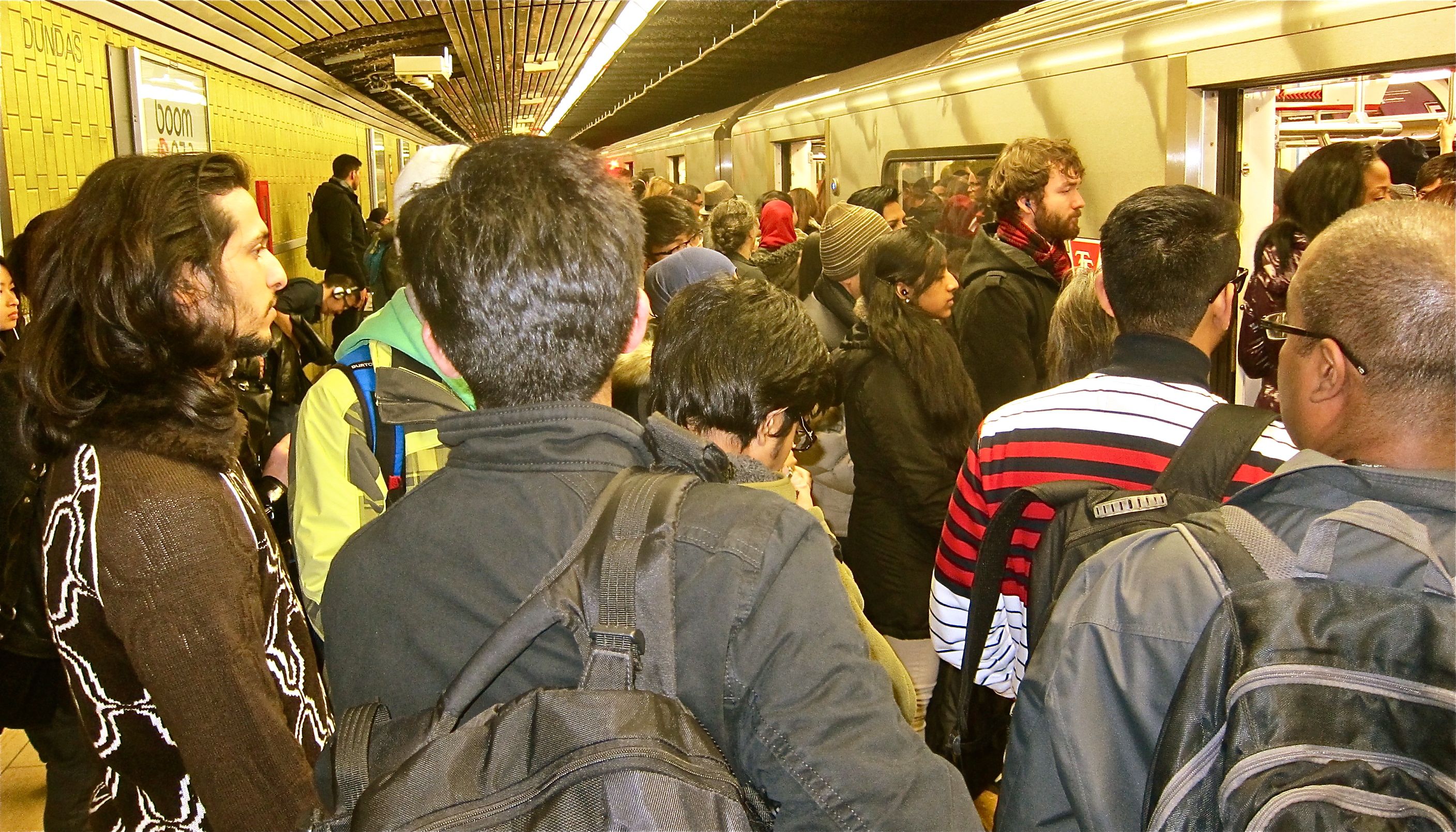
The primary selling point of the SmartTrack plan is that frequent, somewhat-subway-like service on an existing above-ground corridor at a TTC fare could deliver some relief to the overloaded core of Toronto’s subway system far sooner than the never-today/always-tomorrow Relief Line subway can be built (let alone funded). Yet, for reasons that seem not to exist in any available documentation, the area of the proposed SmartTrack route with the greatest potential to deliver that relief to the subway is being left with the longest gaps between stations.

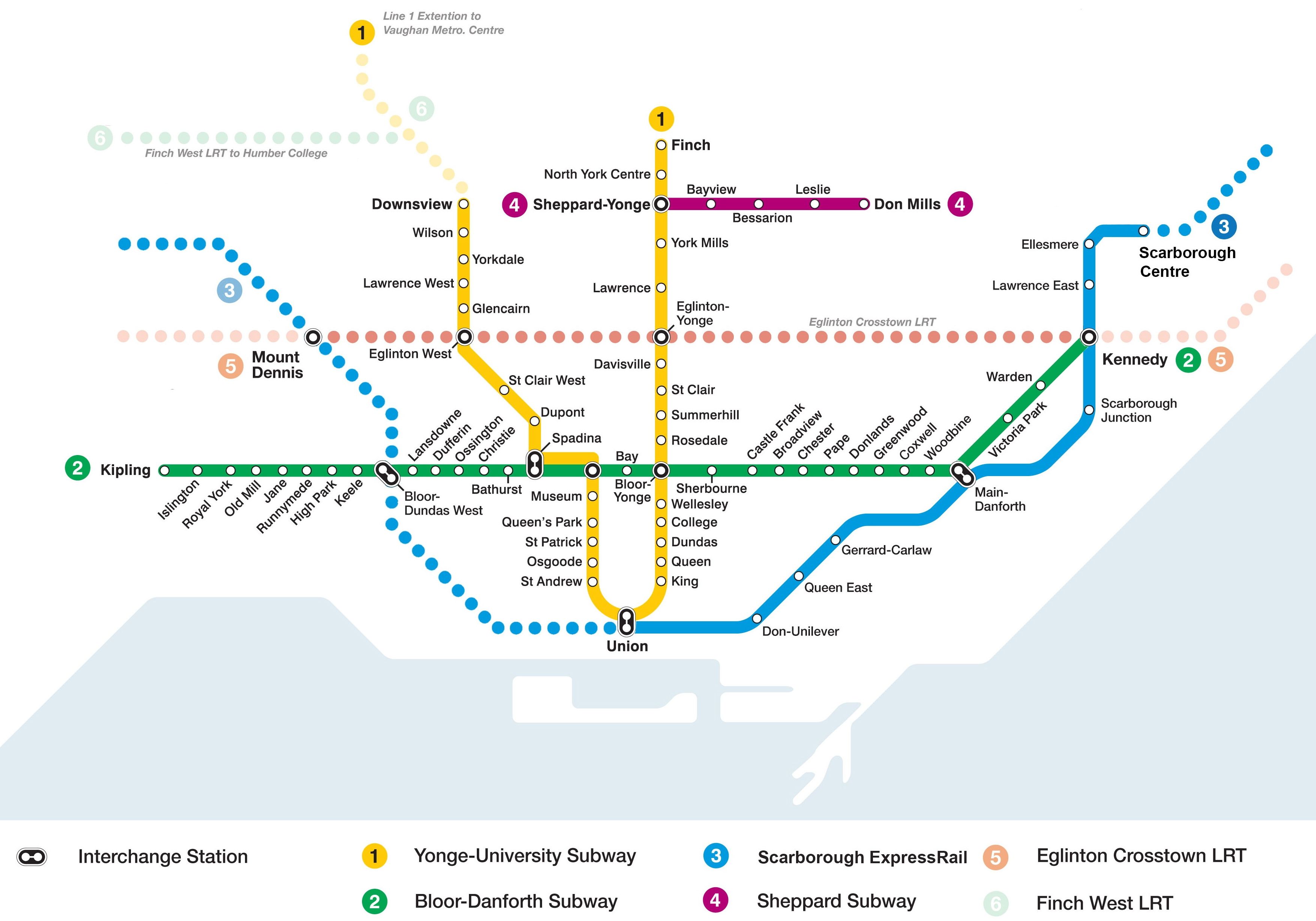
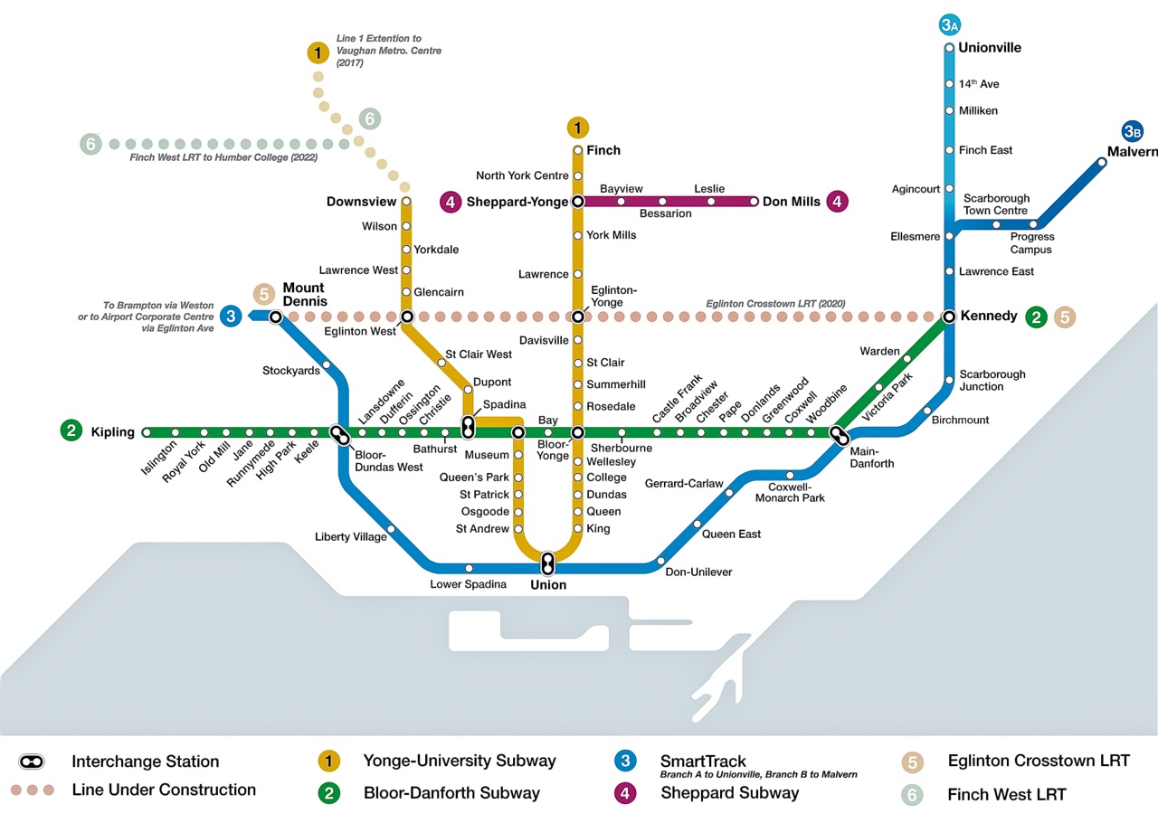
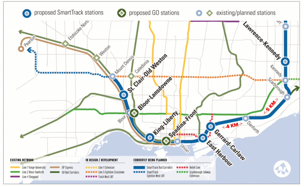
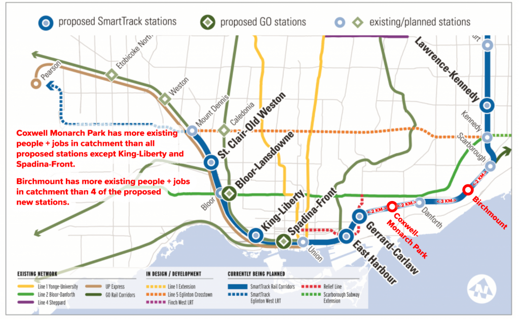
While much of the ST route calls for two-kilometre station spacing, it’s a full four kilometres from the proposed station at Gerrard Square (where SmartTrack might eventually connect with the proposed relief subway line) to the next station east, GO Danforth. (And the next station heading east from GO Danforth is another five kilometres.) The subject came up over dinner with some transit-planner friends a couple of years ago and it was agreed that Coxwell Avenue, roughly 2 km from both GO Danforth and the proposed Gerrard-Square station, seems to be an ideal location for addressing this void. Little did some of us realize that upon looking at the situation more closely we would discover the case for a Coxwell-Monarch Park SmartTrack stop was much stronger than the cases for nearly all of the approved ST and RER stations.


Can something as big as a railway station fall through the cracks?

A few months after that dinner, in August 2016, Metrolinx contacted the Danforth East Community Association about setting up a meeting with community members regarding plans for upgrades to the GO corridor (the southern boundary of DECA’s area). The meeting with DECA’s visioning committee (which I co-chair) took place on Sept. 13, 2016, in the basement of Gerrard Pizza (near Danforth and Coxwell). As expected, area residents raised concerns about noise associated with increased train frequency. And some wanted to know why we were already having to add a fourth track when “it seems like only yesterday” that GO was keeping them up all night with construction to add a third track (it was actually about a decade ago). One woman added: “Why couldn’t they get it right the first time?” (As we’ll see toward the end of this note, there are also valid reasons to question the commitment to getting this bit of the Lakeshore East corridor upgrades right the second time.)

Some meeting attendees, sick of crowding and unreliable service on the TTC, also had some “what’s in it for us?” questions. Possibly seeing an opportunity to deliver good news, the man leading the three-person Metrolinx entourage, eagerly mentioned the proposed Gerrard Square station. He and the other Metrolinx staffers appeared quite surprised when it was pointed out that a station at Gerrard Square – like the TTC’s relief-subway proposal – would be too far west to do much for people who already can’t rely on being able to squeeze into jammed subway trains at Woodbine, Coxwell, Greenwood and Donlands in the a.m. rush.

When asked about the possibility of an ST station at Coxwell, the lead Metrolinx representative replied that he was certain the site had been studied using “strict criteria” and that the idea must have been rejected by experts.

I then asked him to provide me with the reports from that study process, particularly with regard to Coxwell-Monarch Park or a station in the long no-man’s land between Gerrard Square and GO Danforth. He said he would be happy to send me the details and that I should email him a reminder. Thus began a long back and forth for which Metrolinx – nearly two years later – remains unable to provide any such documentation, detailed or otherwise.


What Metrolinx was able to tell us

Anyone who has studied Metrolinx’s many official online reports regarding RER, SmartTrack and the station-selection processes will have read repeatedly that “An initial identification of over 120 potential station sites was narrowed to 56 (it’s 50 in some reports) with supportive infrastructure through a high-level evaluation of transport connectivity, planning and land use and technical feasibility.” Coxwell was listed as a potential station on an initial Metrolinx compilation of 120 potential stops. Coxwell was also under consideration after the list had been winnowed to 50 (or 56, depending the document). At some point after that, but before the initial business case studies began, Coxwell disappears from the list. That’s about the extent of it … unless you consider what I was told by one former Metrolinx staffer (who had yet to leave when the cut-down process and/or any early-stage studies would have taken place), including:

  • I asked the same question of MX Planning [about criteria and results used for eliminating stations early on], as they engaged us in Economic Analysis shortly before they started stage 6 (the business cases) for the short list.  They didn’t do any modeling for the lists of 120 or 50 stations, the decision was subjective …
  • “Remember what [XXXX] said to me during my exit interview: ‘Let’s face it, everyone fabricates the evidence, the city does it, we do it. The new-stations process was always going to be political.’ ” 

The former staffer, as well as two current ones, also mentioned in recent years that even when Metrolinx got around to modeling business cases for the short list, some key criteria that were used were chosen with suburban commuter rail in mind and was thoroughly inappropriate for the urban areas to be served by SmartTrack. They’ve also pointed out that at least one of the technical feasibility rules regarding stations on curves was broken for stations that politicians in positions of power were demanding.

Meanwhile, two senior bureaucrats, one with the city and one formerly with the TTC, have told me that the only stations considered for SmartTrack and for study by Metrolinx were chosen – not through a rigorous professional process – but by advisers to the winning campaign in Toronto’s 2014 mayoral race. And while the current mayor’s office eventually gave in on an obvious flaw in the initial ST plan (the since-killed western spur under Eglinton), it seems apparent that no serious second thought was ever given to addressing potential flaws or better solutions in the SmartTrack plan for the old city’s east end and Scarborough.


The broad east-end transit context

My discussions in recent years with city staff regarding several issues (including the Danforth Avenue Planning Study, the Main Street Planning Study, two individual high-rise development plans for Main and Danforth, Metrolinx’s RER-ST corridor upgrades and SmartTrack itself) have often indicated that the official view from 60 Queen Street West is that the east end of the old city is very well served by transit, and that a relief subway (aimed primarily a dealing with dangerous and off-putting crowding on the Yonge subway and at Bloor-Yonge station) would solve any possible east-end concerns – even if the line comes only as far east as Pape.

And that received wisdom might seem valid if you don’t look much beyond simple maps. But a close look at long-term transit-usage trends in Planning District 6 (the four pre-2018 city wards abutting the Bloor-Danforth subway between Victoria Park and Broadview) indicates otherwise. Most of the key details on this point can be found in these two 2016 columns I wrote for the Beach Metro News:

(Though newer Transportation Tomorrow Survey data have been released since these columns were written, sources tell me there’s a strong chance the data are suspect (with only a 7-per-cent response rate), so I’m hesitant to put stock in the new numbers until a trusted transit data analyst I’ve worked with previously has a chance to seriously study them).


Five key points for understanding the east-end context include:

  1. PD6, despite being an inner-ring planning district that should be easy to serve by relatively low-cost transit for trips to the nearby downtown, has seen transit lose so much market share for such trips that, as of 2011, it had the lowest percentage of transit use for downtown a.m. peak trips of any Toronto/416 planning district (yes, that includes Scarborough, Etobicoke and North York). And, all the while, car usage was on the rise for downtown trips from PD6.
  2. PD6 is the second biggest generator of trips to the core of any GTHA planning district – it’s a market that really matters with major potential for major ridership gains without huge investments;
  3. Since the Scarborough Rapid Transit (SRT) line opened to Scarborough Town Centre in 1985, Bloor-Danforth subway trains have filled up east of PD6, while crowding at the Bloor-Yonge pinch-point becomes increasingly dangerous. And if the proposed multibillion-dollar Scarborough Subway Extension succeeds in attracting more riders to line, the problem will only get worse. A 2014 TTC report shows that the seven stations from Warden to Donlands, inclusive, have been losing ridership in the a.m. peak over the past 30 years, likely due to crowding that won’t be resolved even if a relief subway is ever built.
  4. Areas east of the Don River have only two trunk east-west streetcar lines between the lake and Danforth Avenue, unlike the areas further west, which have five, including major TTC routes on King, Dundas and Wellesley-Harbord (I’d add Queens Quay, but that’s not fair). Furthermore, the two lines that penetrate the east end, the Queen 501 and the 506 Carlton (which largely runs on Gerrard in the east end), have seen service cuts over the past three decades that have resulted in big ridership losses (without helping helping the TTC balance sheet). Because its bordered by the Don Valley on the west and north, PD6’s road connections to the rest of the city are also limited.
  5. GO trains roll through the east end (largely empty outside of the rush hours) without stopping in enough convenient places while charging uncompetitive transit fares. For many east enders, GO trains serve only to disrupt sleep or force conversation breaks when they roar past.

The narrow Coxwell-Monarch Park context

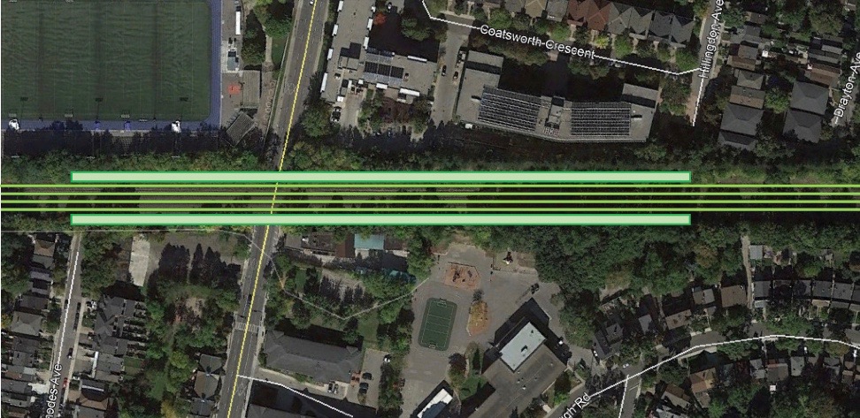
For me, a brisk walker, it’s 25 minutes on foot from the bridge that carries GO trains across Coxwell Avenue to both GO Danforth and the proposed SmartTrack station at Gerrard Square. Taking the TTC to those stations isn’t much faster, at least if my unscientifically small sampling counts for anything. My five weekday trips to or from GO Danforth took 19.5 minutes on average; three test trips to Gerrard and Carlaw averaged 20 minutes and 16 seconds – and, of course, once at those stations another separate fare would be required to travel farther. (Two of the four trips to GO Danforth included nine-minute walks to Coxwell subway station because the No. 22 bus was unable to pick me up before I got to the subway).

Despite talk of SmartTrack offering some relief, station location choices made by the Toronto mayor’s office seemed overly focused from the start on proximity to large development sites and not focused enough on pent-up demand (it was also weird that the initial ST plan would ignore existing need/low-hanging fruit in the mayor’s own city while putting terminal stations in Markham and Mississauga). Some of the errant focus appears to have been spurred by misguided advice that tax-increment financing would be a significant source of revenue for the SmartTrack project. And while politically connected developers aren’t likely to enrich themselves spectacularly in the Coxwell-Monarch Park catchment zone, ingredients essential to the any station’s success (criteria that were to be key in Metrolinx’s short-list screening process) are readily available, including the promise of growth and modest but near-guaranteed development.


Five reasons why Coxwell-Monarch Park is a great ST station location

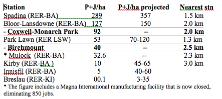
  1. The Coxwell-Monarch Park catchment zone provides real, existing people-and-jobs-per-hectare numbers that are better than five of the six new stations chosen for SmartTrack, with more growth in the works.


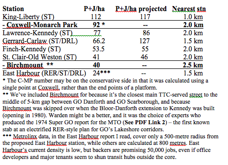
C-MP also fared well when compared with stations Metrolinx and/or politicians at Queen’s Park selected for RER.

The Coxwell-Monarch Park catchment zone’s

  • 16,385 residents total is more than in 37 of Metrolinx’s 51 mobility hubs;
  • 2,132 jobs are more than in nine of the 51 mobility hubs;
  • 18,517 residents and jobs combined, is 85% more than Metrolinx’s 2031 goal for a Gateway mobility hub.
  1. The Coxwell-Monarch Park catchment zone provides development and growth potential. While no “P+H/ha projected” figure is provided for C-MP in the tables above, there is increasing mid-rise development pressures along Danforth Avenue, which prompted the recently completed Danforth Avenues Planning Study. A mid-rise co-op development is already in the works for Coxwell and Upper Gerrard. Also, plans for a second significant employment node on Coxwell Avenue, led by CreateTO, are in the works for the nearly five-acre TTC site at Danforth, including TTC offices, a mega-police station and community amenities. (The first Coxwell node is slightly north of the C-MP catchment zone, and includes 5,000-plus jobs between Michael Garron Hospital and the Toronto-East York Civic Centre). On both sides of Coxwell, directly south of where the station would be, there are two underutilized half-acre sites, depots for U-Haul and a building-materials retailer (and we’re told Ottawa is looking at ways to make it easier to develop such sites adjacent to railway tracks at stations on passenger-only rail lines). We should also add that large numbers of visitors to and from the sports dome and high school immediately northwest of the C-MP station site have caused enough traffic and parking headaches that a study was commissioned (even though it glossed over the need for transit improvements). The study, completed by WSP in July 2017, is here: http://www.tdsb.on.ca/Portals/ward15/docs/1610692701REPMonachPark09062017v12rsrs.pdf
  2. A Coxwell-Monarch Park station would address social equity concerns. There’s a significant amount of nearby assisted-living projects, including – right next to where the station would go – Toronto Community Housing buildings and seniors homes on Coatsworth Crescent and Amik Plaza’s residences for Indigenous Canadians. (Amik Plaza is operated by Wigwamen, which has other residences in the C-MP catchment zone http://www.wigwamen.com/housing/locations/ and has most of its properties in the east end). Wigwamen has written letter in support of a C-MP station. Further away, but still within the pedestrian catchment zone is Tobias House at Danforth, and there are more seniors buildings just west of Monarch Park. We’re talking about lots of low-income people who tend to be transit “captives.”
  3. A Coxwell-Monarch Park station is sited well for transit connectivity: Especially if SmartTrack offers service at TTC fares with TTC transferability, this would be a solid location from Day 1 with good long-term growth potential. At present, the two bus routes that serve Coxwell Avenue handle 55% more riders than the entire Oakville Transit system*. There’s a case for combining the two routes to provide one-seat service all the way from the Beach area, via this proposed ST station and Coxwell subway station, through the hospital/civic centre employment node and all the way up to Eglinton. The case gets stronger as of 2021 when this combined route can eventually link the Eglinton-Crosstown with the Line 2 subway at Coxwell and SmartTrack, likely the only spot in the east end where one bus route could join all three of those key rapid-transit lines.  *Using 2015 data, Oakville Transit carried 2.83 million riders a year. The two TTC routes serving Coxwell (Nos. 22 and 70), handle 14,300 riders on an average weekday, which the TTC multiplies by 306 to get an annual figure, in this case, 4.38 million.
  4. Coxwell-Monarch Park was chosen by experts for the Super GO electrification plan – and that report was produced by transportation professionals – its station-location choices were based on study, not political priorities.

In summary

We have a new provincial government and new ministers of Environment and Transportation, both of whom are people who should see the need to restore the public’s faith in transportation-planning processes. Ontario’s competitiveness and sustainability hinge to a significant degree on regaining a trust damaged by politicians at all levels who interfered with the public service’s ability to fearlessly prepare menus of options, objectively pull together and analyze evidence, and use their professional expertise to speak truth to power. The case of Coxwell-Monarch Park appears to be strong and appears to have fallen through the cracks because of flaws and corruptions in the process. While it would be inappropriate to ask for politicians to demand that this station be added to the SmartTrack project – despite the strong evidence – it’s a crucial matter of provincial interest (municipal and federal, too) that thorough study be done that a) examines the merits of this specific potential station and b) looks seriously at how it could possibly have been overlooked so we can learn from our mistakes and get better results from the processes in the future. And while the lack of a station at Coxwell-Monarch Park might not have a negative impact on a “constitutionally protected Aboriginal or treaty right,” as the criteria at this stage of the process word things, it’s clear that the process has failed people who need better transit and live in the immediate pedestrian catchment zone of this proposed station, including Aboriginal people of Toronto. 


Five quick supplementary points we should make in closing

  1. While SmartTrack has cost and time-frame advantages to offer in a city and metro area that is way behind in building transit infrastructure, it in no way obviates the need to get on with a major new rapid-transit line through Toronto’s core that does not add to the crowding at the Canada’s two busiest transit stations, Bloor-Yonge (415,000 daily platform movements) and Union (275,000). This new major line would most likely be the so-called relief line that has been talked about for more than a century and which has been the top priority of knowledgeable transit people on and off for 50 years. At best, we should be looking at SmartTrack as a plan for borrowing capacity that can temporarily be made available on Metrolinx’s surface corridors and at Union to address urgent needs, understanding that Metrolinx must deal with huge regional growth and will almost certainly need it back.
  2. We should be thinking long-term with regard to the corridor upgrades, looking to what its maximum capacity can be and planning to ensure we can scale up to achieve it at the best price. Metrolinx has been taking an incremental approach, adding a third track on LSE to Scarborough last decade and preparing to add a fourth now. While my sources are not unanimous on this, it would seem they think we should be looking at how we’re going to get to five tracks from Union to Scarborough if we end up with a not-unlikely runaway success akin to London Overground. One respected Metrolinx source says we can do all the local and express service we need with four tracks, while others (Metrolinx and outside), say a fifth track is almost certainly going to be needed sooner or later because the corridor has to serve Via, provide redundancy and anticipate demand growth, and that preparing for it now is better for taxpayers and the residents who have to endure construction in their neighbourhoods. It’s worth noting that the 1974 SuperGO electrification report was calling for five tracks Union to Scarborough.
  3. It’s time to get serious about making the vast swaths of asphalt surrounding outer GO stations into destinations for much more than parking. If we don’t give people many good reasons to be on outbound trains in the a.m., RER’s new operating costs are going to swamp its revenues. Some elements of MTRC’s land-plus-property business model is likely the route to take, allowing a Crown corporation to professionally manage a massive real estate portfolio and earn returns for Metrolinx on the public’s investments. Done right, we can defray transit capital costs while expediting operating efficiencies. These lands also need to be the top/only choices for new developments with a public interest such as universities, colleges, hospitals, casinos, etc.
  4. In the period leading up to the rollout of RER, it’s worth doing a pilot project whereby all transit trips that begin and end within any one GTA municipality have fares capped at that municipality’s single fare. Because it would allow GO and the various local transit agencies to start fully supporting each other, the potential ridership increases might offset the revenue losses to a greater degree than might be expected. We can gain valuable real-world information about the transportation market and how transit can work more efficiently. It should help us to do fare integration intelligently. It should also offer significant rewards at a low risk because, as a pilot, it would have a termination date, if necessary.
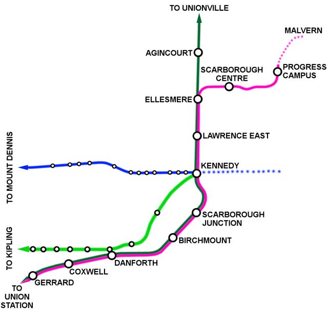
  5. Though I’ve focused on Coxwell, the City of Toronto would be wise to look at how the Birchmount area can be developed. It’s numbers are decent, and it’s an area not at all well-served by transit at present. There are also huge underutilized sites. An ST station there (or near Warden and Danforth as proposed in the 1974 SuperGO report) could be a useful catalyst.


Notes on the contexts for some of the proposed new ST and RER stations

Lawrence-Kennedy is in PD 13, the eighth-biggest market for trips to PD1 (downtown). Transit already has a 75% market share of the trips to PD1, with 11% of the trips being made on GO. The station’s importance rests to a significant degree on the fact the Scarborough Subway Extension plan does not include a station at Lawrence, connecting with Lawrence bus. Prospects for creating new transit riders for trips to PD1 appear limited, though the station has been approved for ST even if the broken out business case has been questioned and was rated “low performing”.

Finch-Kennedy is in PD 16, the ninth-biggest market for trips to PD1. Transit already has a 79% market share, with 16% of trips made on GO. Prospects for creating new transit riders for trips to PD1 are  limited in the short term, though Milliken Square Mall and a Public Storage facility present lots of longer-term development land. The station has been approved even if the broken-out business case has been questioned (costs outweigh benefits).

Coxwell-Monarch Park is in PD6, Toronto’s second-biggest market for trips to PD1 (downtown), though transit has only a 52% market share – the lowest of all Toronto planning districts. Less than 0.5% the trips to PD1 are made using GO’s corridor, which runs PD6’s full length. PD6 generates 19% more PD1 trips than PDs 13 and 16 combined, while transit in PD6 has a 31% lower market share of PD1 trips. Not building a station leaves a 4-km gap in an area where SmartTrack may have its best potential to relieve Line 1 and Line 2 crowding. With a 700-metre extension of the TTC’s No. 70 bus, C-MP would connect directly with two routes that carry 55% more daily riders than the entire Oakville Transit system and would link C-MP with an employment hub (5,000+ jobs) at Michael Garron Hospital/East York Civic Centre. This C-MP station would also be 300 metres from a stop on the 506 Carlton streetcar, which carries 40k riders daily. C-MP should score well on Social Inclusivity and Accessibility, having a large TCHC development immediately to the northeast and assisted housing to the immediate south. The site has several development sites within its 800-metre radius area, including Danforth Garage, a.k.a. Coxwell Barns (five acres at Danforth currently undergoing a master-planning process under the aegis of CreateTO), a new building approved at Upper Gerrard and Coxwell, a 0.6-acre site next to station being used for U-Haul vehicle storage and a 0.5-acre building materials site where station entrance would be. How C-MP missed the list of 50 stations that qualified for IBC screening, let alone the short list, is a mystery (even to some Metrolinx staffers who cannot speak on the record). With high current density, travel patterns and low transit-market-share penetration, prospects for creating new transit ridership for trips to PD1 and helping relief effort appear to be very strong at C-MP station.

Birchmount is on the PD13-PD14 boundary. PD13 is the seventh largest generator of trips to PD1 and transit captures 75% of them, in part because it contains Kennedy station, probably the GTA’s second best transit-served hub. PD14 is the 11th biggest generator of trips to downtown, so the market is smaller than average. But there is considerable room for growth as transit captures only 55% of the market share for PD1 trips (third lowest of all PDs), and 30% of the transit trips to PD1 are by GO. Current density in the 800-metre radius is fairly low (but greater than nine of Metrolinx’s 51 mobility hubs). There’s lots of nearby developable and underutilized land, though much of it is exclusively “employment” meaning it would be a challenge to create the mixed-use urbanism in the short term. Birchmount is also within 800 metres of a Neighbourhood Improvement Area, one of the criteria Toronto wanted considered for ST consideration. Prospects for creating new transit ridership are moderate short term, but the potential could be big with zoning changes that allow for development of the Birchmount strip between Danforth Avenue and Danforth Road. Not having a station here leaves 5-km station gap, far too long for connectivity in an area that has transit needs. PD14, in particular, is starved for transit to PD1

St. Clair-Old Weston is in PD3, the fifth-biggest market for trips to PD1. Transit has a 62% market share, but less than 0.5% of trips made on GO. Site borders on huge amounts of former stockyards lands that have been converted to car-dependent big-box retail. Despite current low density, prospects for creating new transit riders for trips to PD1 appear good short term due to apparently unsatisfied demand in PD3. The developable Stockyards land (RioCan property) would require major rezoning and total urbanizing, something that could be done, though our record on such initiatives in Toronto is poor.

Park Lawn is in PD7, the 11th-biggest of 15 markets for trips to PD1. Transit has a 59% market share, and 35% of the trips are made on GO. People-plus-jobs density is not high, at least using the 2011 data that’s referred to in Metrolinx’s reports. But residential density will likely continue to grow considerably for a few years. There are concerns a new station would cannibalize ridership at Mimico and that a replacement of Mimico (especially after recent investments in Mimico station) would be a waste. The closeness of the stations should not be a major concern in that 1-km station spacing (along with flat and transferable TTC fares) may eventually prove to be essential to getting SmartTrack to its full potential. Prospects for creating new ridership for trips to PD1 look moderate, but they’re probably very good long term. The proximity of Mimico station and the lack of office-employment prospects on the old Christie bakery site would seem to indicate there there’s no rush to build this station. Trying to track down 2016 census data because things are changing fast.

Mulock In 2011, the population and employment density within 800 m of the potential Mulock station was estimated to be 32.6 people and jobs per hectare (P+J/ha). The job figures would have included the Magna facility, which is now closed, eliminating 850 jobs. There are two active development applications located within proximity of the potential Mulock station, both of which are minor in nature and do not represent a significant increase in density or change in land use: A new Shoppers Drug Mart store proposed for the northeast corner of Yonge Street and Savage Road; and 28 townhouses proposed on Silken Laumann Road.

Breslau This station was deemed to be high performing in Metrolinx’s rankings, but this report raises questions about how it could possibly have achieved such a label.

http://www.metrolinx.com/en/regionalplanning/newstations/IBC_Breslau_EN.pdf

The report says on page 14: “In 2011, the population and employment density within 800m of the potential Breslau station is estimated to be 0.1 people and jobs per hectare (P+J/ha). The lands surrounding the potential station are currently rural/agricultural and contain only a few houses, a church and a few businesses. Figure 4-1 illustrates the current land use permissions for the proposed station site and surrounding area. In 2006, an estimated 72 residents and 43 jobs were located within 800 metres of the potential Breslau Station. Projections from the Ministry of Transportation Greater Golden Horseshoe Model suggest that by 2031 the population and employment within the Station area may reach 334 and 209 respectively. [1] However, recent changes to policy and planning objectives have resulted in substantially higher population and employment forecasts for the Breslau area. Figure 4-2 shows where recent development has occurred and where development is anticipated within the Secondary Plan Area. The Draft Plan of Subdivision submitted to the Township by Thomasfield Homes shows that in addition to a new GO station, the following will be accommodated on its 94.9 net developable ha of land: 2,535 people; and 2,830 jobs (i.e. 24.6 acres Employment Land (2,450 jobs), 3.7 acres Commercial (116 jobs), 4.9 acres Mixed-Use Commercial (153 jobs) and 3 acres Institutional (40 jobs).” … “Given that the potential Breslau station is located within an undeveloped area, there are no ‘soft sites’ within 800 m of the potential station. Soft sites are considered to be parcels with a relatively high potential for change, such as parking lots and under-utilized sites given current zoning and the Official Plan designations. A new residential subdivision is being completed approximately one km east of the potential station site and considerable new development is underway or planned elsewhere within the Township and the larger Region of Waterloo.

https://observerxtra.com/2016/11/24/omb-upholds-woolwichs-staging-plan-breslau-subdivision/ Breslau plans would bring 6,710 people + jobs to the catchment, roughly 31 per hectare. Strangely promotional language in a Metrolinx document about Waterloo’s connections with Toronto. http://www.metrolinx.com/en/greaterregion/regions/waterloo-wellington.aspx

Innisfil This station is also deemed to be high performing, apparently based on some longer-term projects. From Page 13 of this report

http://www.metrolinx.com/en/regionalplanning/newstations/IBC_Innisfil_EN.pdf

“The existing population and employment density within 800 metres (m) of the potential Innisfil station is estimated to be 5 people and jobs per hectare (P+J/ha). While currently the area does not meet Metrolinx Mobility Hub. Guidelines for rapid transit, significant population and employment growth is anticipated for the South Alcona area. The draft Secondary Plan, which is under appeal, shows a Phase 1 population of 7,200 people and 1,100 jobs. Growth projections for Phase 2 will be subject to each five-year review of the Town’s Official Plan in the future. Figure 4-1 illustrates the land designations from the draft South Alcona Secondary Plan. Surrounding lands are largely designated ‘Agricultural Area’ and will not contribute to the local area density. When fully built, the South Alcona area is intended to have an overall gross density of 67 P+J/ha. Some of the proposed medium density and commercial areas are slightly outside the 800 m station radius. Assuming full buildout future densities within 800 m of the Innisfil station would be 40 to 60 P+J/ha.

Categories
East End Toronto Toronto Transit Uncategorized

No matter how much the TTC paid for the KPMG report, it paid too much

Don't know who put the Frank Zappa billboard up on the side of the building containing the Leslie Barns project office, but his words seem mighty appropriate.
Don’t know who put the Frank Zappa billboard up on the side of the building containing the Leslie Barns project office, but his words of wisdom seem mighty appropriate.

By STEPHEN WICKENS

The obvious irony is that a consultant’s report released in September 2016, advising the Toronto Transit Commission how to complete capital projects on budget and on time, missed its deadline by 10 months.

We don’t know if there was a set budget, and weeks of trying to find out merely how much the public paid has turned up nothing: The city told me to ask the TTC, while the TTC replied, sorry, “the city commissioned it.”

The consultant, KPMG, also didn’t respond to requests for comment on what it billed and why it took such a soft approach to investigating troubled projects – including the Toronto-York-Spadina subway extension (TYSSE), the Leslie Barns streetcar facility and new signalling systems for the Yonge-University-Spadina subway.

Apparently, the city seems happy with KPMG’s work and the TTC has agreed to adopt all 41 recommendations, including calls for “gate-keeping” at key stages on future projects, clearer definitions of management responsibilities and better processes for documenting and monitoring progress. Local media gave the report a quick and soft once-over, and likely won’t return to the matter.

But does this report get us any closer to delivering bang for the buck on transit projects?

A public angered by fiasco after fiasco on the transit capital file might ask why KPMG ignored the many people who warned early on that these projects were off the rails.

KPMG didn’t talk to David Gunn (the most-respected TTC chief in recent decades). Gunn, in 2011, told the TTC, politicians and Globe and Mail readers the signalling project was in deep trouble and that the grandiose, stand-alone stations on the TYSSE made no sense. He also advised TTC leaders to rethink the Bombardier streetcar purchase decision that has turned out to be so problematic.

In a recent discussion, Gunn pointed out that if the TTC had listened and opted for proven 70% low-floor vehicles instead, it would have saved money and grief and wouldn’t have needed the Leslie Barns maintenance facility at all. And if KPMG had talked to those who can say “I told you so” on Leslie Barns, it wouldn’t have swallowed the “scope creep” excuse for cost overruns (a botched site-selection process made the utility relocations necessary, setting off a chain reaction of cost escalations).

City councillor Mary-Margaret McMahon labelled Leslie Barns “a boondoggle” on her first day in office in 2010, but was repeatedly ignored by the TTC and fellow politicians. KPMG didn’t contact her either.

Seeking alternatives, McMahon assembled a group that included globally respected transportation engineer Ed Levy. If KPMG had spoken with him (or others in the group, including me) they might have learned the city – blinded by the prospect of getting 18 acres from the Toronto Port Authority for $1 – encouraged the TTC to skip international best practice’s Step 1 in picking sites for such facilities: minimize the deadheading or the number of unproductive kilometres. Toronto is now locked unnecessarily into an operating setup retaining wasteful commutes to get vehicles into and out of service, especially on the 509, 510, 511 and 512 routes.

Absurdly grandiose stations on the Toronto York Spadina Subway Extension were part of the reason the project is late and far more expensive than it should be. David Gunn warned us about the problem six years ago, but KPMG didn't bother to interview him.
Absurdly grandiose stations on the Toronto York Spadina Subway Extension were part of the reason the project is late and far more expensive than it should be. David Gunn warned us about the problem in 2011, but KPMG didn’t bother to interview him.

As for that too-good-to-be-true $1 site, a commercial real estate executive with the company then known as Barnicke told McMahon’s people the most it was worth – “if level, clean, approved and desirable for commercial redevelopment” – was $15-million. Cushman & Wakefield, the real estate consultants the Port Authority hired to assess the worth of the site put the value at $1, if it was left fallow for future parkland (trying to develop it would bring hugely costly liabilities into the equation).

In the end, the TTC paid more than 10 times the best-case $15-million price just to make the site usable. Connecting tracks alone cost 7.5 times the estimate the TTC used to justify the site choice.

KPMG states that costs escalated because of delays in awarding contracts; the hard truth is that costs soared because of haste to award contracts for an ill-conceived plan. There was a concerted effort to ignore informed people who were raising red flags.

On the TYSSE, some warned at the conceptual stage that it was nuts to push subway into Vaughan and bore deep tunnels through low-density areas. GO trains on the surface would have better served York Region’s rush-hour commuter rail needs. (You can read about the backroom politics that put the TYSSE into play in former provincial cabinet member Greg Sorbara’s memoirs).

So, how did KPMG investigate? It interviewed “68 key personnel and stakeholders at the City of Toronto, the TTC and from external organizations, including key personnel for each of the projects” – most, we can assume, are people with vested interests in minimizing the embarrassment that should accompany projects gone awry.

The report even includes a disclaimer that KPMG “neither warrants nor represents that the information contained in this document is accurate [or] complete.” (Imagine a newspaper that relies solely on the veracity of news releases and PR people?)

There’s some good (but blindingly obvious) advice in KPMG’s 200-plus-page report, but it ignores probably the most important truth: The world’s best project management cannot save bad projects.

Or, as Gunn put it: “There’s no magic to this stuff. You need a small, strong, informed group of managers, and the person at the top has to have the balls to stand up to politicians when they insist you do stupid stuff.”

Categories
East End Toronto Toronto Transit Uncategorized

Why not remove the Scarborough subway stops altogether?

Something lost on most tourist is that 55% of London Underground is actually above ground, and for good reason
Something lost on most tourists is that 55 per cent of London Underground is actually above ground, and for good reason. Toronto seems to have forgotten why it usually makes little sense to tunnel for subways in low-density areas; we didn’t even tunnel between Bloor and Eglinton in the era when we were good at planning and building subways.

By STEPHEN WICKENS

If eliminating subway stations to save money is the way to go, why haven’t we pondered going all the way? Why not a no-stop Bloor-Danforth extension in Scarborough?

I’ve been asked repeatedly what I think of the January 2016 transit compromises (and some have also asked whether the plan might give us the world’s longest stretch between stations on a tunnelled subway).

I love the idea of cutting unnecessary expenditures, and I fully back the reallocation of resources to Eglinton-Crosstown extensions. But the one-stop subway idea requires serious re-examination.

Extra long access-free underground corridors, though rare, are useful and are used in extremely special cases. The question is: What makes Scarborough so special?

Moscow has a 6.6-kilometre tunnelled stretch with no intermediate stations between Krylatskoye and Strogino on the Arbatsko-Pokrovskaya (Line 3). That’s 900 metres longer than the uninterrupted stretch proposed as a Bloor-Danforth extension from Kennedy to Scaborough Centre under Eglinton Avenue and McCowan Road, but it is used to protect Serebryany Bor forest on the city’s western flank.

Geography also explains the 9.6-km ride from Embarcadero to Oakland 12th Street on the BART. That’s two-thirds longer than our Scarborough gambit, but not even the looniest Toronto politician would consider stations under San Francisco Bay – or would they?

A definitive list of global examples on this scale would be short, but the fact we’re considering joining the club without a geographic barrier says lots about the perceived level of political crisis over Scarborough, as well as the strange obsession some locals have with tunnelled transit.

Widely spaced stations on the world’s great systems aren’t rare in themselves, it’s just that they’re almost always above ground, such as the 6.3-km stretch between Chesham and Chalfont & Latimer on London’s Metropolitan line (upper-left corner of your Tube map).

Sane cities rarely tunnel once their subway tentacles spread beyond dense cores. Fifty-five per cent of the London Underground is actually above ground. Honest!

MTR Corp. of Hong Kong, which in recent decades has been the international gold standard in terms of combining an urban transit business model with great service and continual system expansion, is 62 per cent above ground.

Our ancestors – Torontonians who who survived the Great Depression and helped win World War II – got this, and their wisdom and sacrifices left us the basics of a very good system (at least in North American terms).

Their Toronto was much smaller and poorer, yet they built good subways – and did so without funding from Queen’s Park or Ottawa. They opted for open trenches between Bloor and Eglinton on the Yonge line (since covered between Summerhill and St. Clair). They used shallow cut-and-cover box tunnels to keep costs down on most of the rest of the early system – the parts that now need relief.

Now, we’re too good or too rich for such economy measures. Cut and cover is messier and often requires expropriations, but it allowed our ancestors to hit budgets and deadlines. They built the University and Bloor-Danforth lines (Woodbine to Keele), 16 kms and 25 stations in just 75 months. That’s less time than we’ve spent so far on the 8.6-km six-stop, wildly over-budget Spadina-York extension.

The generation that survived the Depression and helped win the Second World War, came home and made more sacrifices for future generations by ripping up Yonge Street for a subway we all need and need to relieve. TORONTO ARCHIVES PHOTO

The wise elders only considered corridors that could justify lots of stations. The one-stop Scarborough idea is about the same distance as Queen to Eglinton on the Yonge line, and Woodbine to Yonge on the Bloor-Danforth, stretches that comprise 10 stations, eight of them intermediate. Yonge to Keele, also about 6 kms, has 11 and nine of them intermediate.

Of course, once subway tunnels get very long, they require emergency exits, one for every 762 metres. TTC admits this Scarborough idea would need eight of them, and while they’re cheaper than stations, they’re very expensive. (The extension will also go under West Highland Creek three times and have the deepest station on the TTC system, incredibly wasteful design). Those who ran Toronto in the 1950s and ’60s would tell us that if three stations are too many for the Scarborough plan, it’s not a logical subway idea in the first place (whether it costs $3.56-billion with three station or $2.1 billion with one … and certain to start rising again).

And our ancestors come to those conclusions even if there weren’t a cheaper option in replacing the SRT rolling stock and rebuilding the bend, or massive potential at a good price in the Scarborough ExpressRail/SmartSpur option – which the city is now afraid to study because it would undercut the sacrosanct subway plan. See the Star’s Royson James.

Our ancestors would also warn us that it’s crazy to even start on Bloor-Danforth or Yonge extensions until after the Relief Line and/or some variation of SmartTrack is up and running (tiny, cramped Bloor-Yonge station is dangerously crowded, handling 30% more riders daily than the busiest stop on the London Underground (three-line Oxford Circus station).

A no-stop subway? Obviously it’s an absurd idea, but only slightly more-so than the one-stop proposal considered sacrosanct by politicians eager to saddle us with yet another public transit blunder.

We have better options, and the best way to thank those who left us a great legacy is to do great things for our descendants, people who’ll need to get around Toronto and its suburbs long after we’re gone.

Stephen Wickens is a veteran journalist and transportation researcher.

Categories
East End Toronto Toronto Transit Uncategorized Urbanism

We can give Scarborough even more rapid transit for less money by tweaking SmartTrack

Strategically piggybacking onto Metrolinx’s upgrades will help us better nurture urbanization at Scarborough Centre while freeing up capacity on the overloaded inner-city subway system. Extending the Bloor-Danforth, no matter how many stations we include, aggravates the crowding in its best-case scenario.

Scarborough ExpressRail

By STEPHEN WICKENS, ED LEVY and STEVE FRY

—————————————————————————————————-

NOTE: Even though the SmartSpur/SER option would make Mayor Tory’s SmartTrack idea far more useful to east Toronto than in its originally conceived form, it proved to be such a threat to the one-stop Scarborough subway’s viability that all study of SmartSpur was killed on March 31, 2016, at city council after some backroom arm-twisting.

—————————————————————————————————-

One city councillor declared peace in our time and if we weren’t well into the 21st century a hat-tossing ticker-tape parade might have seemed appropriate.

Maybe a tad premature, but what a month January 2016 has been on the transit file: The mayor accepted evidence that SmartTrack’s western spur doesn’t make sense, while city planning said it will study a transitway on King Street. In Scarborough, planners and politicians claim to have found $1-billion to reinvest in Eglinton-Crosstown LRT extensions – west toward the airport and east from Kennedy to the U of T campus. (Environmental assessments are already done for those extensions, meaning plans could be shovel-ready in time to qualify for the new federal government’s promised infrastructure program.)

Can it get any better?

Excuse our sunny ways, but yes it can if John Tory is willing to re-examine how SmartTrack best piggybacks onto Metrolinx’s Regional ExpressRail in Scarborough. According to well-placed sources who’ve contributed to a new report, RER upgrades in the works will permit at the very least 14 trains an hour in each direction between Union Station and Markham. RER needs only four trains; what can we do with the other 10 or even 12?

Before SmartTrack was a gleam in the mayor’s eye, transportation researcher Karl Junkin was examining GO electrification possibilities for think tank Transport Action Ontario (the Star’s Tess Kalinowski wrote about his work in 2013). Further study now confirms one piece of TAO’s report, branching a line off Metrolinx’s tracks east to Scarborough Town Centre (almost following the current, near-defunct SRT corridor), is not just doable but can be done for $1.1-billion. That’s $1.4-billion less than the estimate for the one-stop subway idea that made news last week – $2.4-billion less than the previous three-stop plan.

Junkin’s idea, known to some as SmartSpur but now rebranded as Scarborough Express Rail (SER), can make the east part of SmartTrack smarter than the mayor ever dreamed. Aside from saving money, benefits are huge for many stakeholders if we link Kennedy to STC using GO’s corridor instead of tunnelling under Eglinton Avenue and McCowan Road.

– Scarborough residents would have a one-seat ride downtown from STC without transfers at Kennedy or Bloor-Yonge. Time savings to Union could be as much as 20 minutes. SER would include Lawrence and Ellesmere stations (and could add ones at Birchmount and Coxwell-Monarch Park).

– Residents of East York and the old city who have trouble boarding jammed Bloor-Danforth trains in the morning rush hour at stops west of Main Street would get more capacity. Thousands fewer would squeeze through overcrowed Bloor-Yonge station onto the otherwise unrelieved lower Yonge line. Compare that with making the Bloor-Danforth longer, which would only aggravate crowding for all concerned (if it doesn’t drive more people out into other modes of transportation).

– Short term, for those working to urbanize Scarborough Centre, SER’s one-seat ride to the core provides only a small advantage over a direct tunneled link via the Bloor-Danforth. But SER has much greater long-term potential as it can easily be extended north and east to Malvern on the route previously reserved for LRT ($1.4-billion can certainly get us  to Centennial College’s Progress Campus).

Toronto’s playing catch up, but urgency may finally be focusing minds in high places. We now have a mayor big enough to admit when he’s wrong, while city staff have taken over transit planning from the TTC and appear open to creativity (criticize the one-stop subway idea all your want, but if nothing else it has broken a political logjam). Maybe Metrolinx will get aboard and save us another $500-million by keeping the Crosstown LRT on the surface, rather than tunneling into and out of Kennedy station.

Yes, capacity at Union will be seriously constrained by RER and SER, further increasing the urgency of another subway through the core and up into Don Mills (the long-dreamed-of Relief Line). In the wake of the Spadina-York extension fiasco, Toronto needs a total rethink of the business and design models used for subways. We also fear the province’s RER’s operating costs will be dangerously high if we don’t soon get serious about turning suburban GO station lands into multi-use destinations, but even on that front real estate presents revenue-tool opportunities.

We have big challenges, but we’re suddenly on a bit of a roll, exhibiting flashes of creativity and civic self-confidence not seen in a half-century. Let’s keep the momentum going.

Stephen Wickens is a veteran Toronto journalist and transportation researcher. @stephenwickens1

Ed Levy PEng and transportation planner, co-founded the BA Consulting Group and is the author of Rapid Transit in Toronto, a century of plans, projects, politics and paralysis

Steve Fry is president of Pacific Links, which connects Asian, European and North American entrepreneurs and investors. His consulting work has involved infrastructure project funding in Asia. pacificlinks.ca


Categories
East End Toronto Toronto Transit Uncategorized

Creating feasible options for Davenport will be a true test of urbanist creativity

It’d be great if there were a way to make a north-south tunnel work for Metrolinx’s Bradford/Barrie corridor in the Junction, but it appears as if it’s time to move on and make the most of the infrastructure and train traffic from the inevitable and largely supportable Regional Express Rail proposals

STEPHEN WICKENS

Residents of the Junction are like cousins to us here on the East Danforth; we experience many of the same conditions. There may be much less grime, odour and noise since industry moved out to the sprawl lands in the second half of the 20th century, but our secondary mixes of land use never really recovered from the loss of jobs.

You can see the unintended consequences on our main streets – too many empty storefronts, too many commercial tenants that aren’t a great fit for a hood that seeks better. Neither area was ever a really pretty, but when lots people could walk to work, or when many people came from other parts of town to work in our areas, the shopping and the services and the opportunities for socializing and play just kind of happened. Local merchants and restaurateurs got many more reliably productive hours out of each day.

That’s when urbanity’s beauty is tough to ignore. Our future may now rest heavily on office jobs, but we shouldn’t forget ancestors who gladly made homes next to the smokestacks.

The Junction and the East Danforth were both healthy blue-collar neighbourhoods back when rails lured factories. Now, the tracks are mostly barriers to pedestrian-scale connectivity, fenced off for our safety but undercutting local economic activity. They don’t carry much freight any more and GO’s unnecessarily loud diesel locomotives pull or push trains through without stopping (or when they do stop the fares aren’t competitive).

Metrolinx now owns these tracks and they are slated, rightly, to make possible GO’s Regional Express Rail plan, complete with quieter, cleaner electrified trains that make many more stations possible without slowing the service. The former industrial neighbourhoods of this city would be wise to find ways to make the best of this situation, and smart politicians and bureaucrats will find ways to help us.

Options for Davenport (@Opt4Davenport) and Ward 18 Councillor Ana Bailao (@anabailaoTO), have led the charge to convince city council that we should study a tunnel option on GO’s Barrie corridor rather than meekly accede to plans for 1.4 kilometres of elevated track to get the line past a dangerous and constrictive rail-on-rail level crossing with CP’s east-west corridor.

I get it and I’m sympathetic for a couple of reasons.

1) RER will also bring huge amounts of rail traffic to areas along the East Danforth, upwards of 300 East Lakeshore, Unionville and SmartTrack trains a day along an embankment that divides our communities. That’s more than twice the traffic the Junction will face and it’s about a block from my house (GO trains sometimes rattle the picture frames on my bedroom walls);

2)  I remember the shock and passion from talking with Junction residents when I wrote about the GO’s Barrie corridor plans for The Globe and Mail in September, 2003.

Twelve years and three months later, politicians, bureaucrats, residents and planners seem to be acting as if this proposal is something new. Suddenly, its an emergency and we apparently don’t have time to consider our options.

The tunnel that city council voted to study on Dec. 10, 2015, probably doesn’t stand a chance, though I’d love to be wrong.

Two of the GTA’s most respected transportation engineers examined the The Bradford Corridor Planning Study Final Report (dated March of 2002) for me in 2003 and they agreed with Delcan’s conclusion that the tunnel option wasn’t feasible. Not only would the underground portion have to start south of Bloor to get the GO trains under the Bloor-Danforth subway, rising topography due to the old Lake Iroquois shoreline would mean the tunnel would have to be very long and costly north of Bloor.

One of the engineers suggested that co-ordinating the West Toronto Diamond work with Davenport Diamond might be the best solution (for everybody but Canadian Pacific Railway). But West Toronto Diamond, which was still in the planning stages then, has now been built and the potential opportunity has been lost.

But maybe we can find solutions to make this inevitable elevated line much more than palatable. Maybe, with GO’s electrified trains encased in some funky overground tubes there might be room for porous and lively spaces below — places that can lure pedestrians for many reasons at different times of the day to what is at present a community-deadening barrier.

Maybe it’s an opportunity for an international design competition. In the digital age launching a global brainstorming initiative should be easier than ever, and  it’s not as if creative people aren’t right under our noses here in the Junction and on the East Danforth.

Let’s make sure politicians and bureaucrats help us out.


Categories
East End Toronto Toronto Transit Uncategorized

While many fixate on the Unilever site, our Kennedy lands languish in purgatory

An aerial prospective of Kennedy station from the crosstown.ca website.
An aerial prospective of Kennedy station from the crosstown.ca website. The site cautions that “the renderings are subject to change and may not reflect the final design.” Let us pray.

Our traditional approach to public real estate, especially properties at our major transit stations, involves giving away huge amounts of value to private developers (or wasting it on surface parking), while world leaders are working to master land-value capture and land-value trade relationships.

By STEPHEN WICKENS

What if First Gulf controlled the land surrounding Kennedy station, 25 publicly owned acres that for decades have been served by subway, SRT, GO trains and multiple bus routes. It’s a site whose potential value has soared recently, what with the Eglinton-Crosstown LRT to open in a few years and a reasonable likelihood a Scarborough subway extension and the Mayor’s SmartTrack will roll too.

Add in tracts of nearby, largely undeveloped private lands, and the Kennedy site’s size rivals First Gulf’s Unilever (now renamed East Harbour), which sits behind various moats – river, highway, rail corridor, monolithic land uses and long blocks. Unilever might eventually get lots of transit, but even if Broadview is extended south and a bridge to the West Donlands is added, stitching that site into the urban east-downtown fabric effectively will be a massive challenge.

The comparison’s timely because one site needs urgent attention – and despite media coverage and city hall chatter, it is not Unilever. Kennedy was the natural site for a “downtown” or “centre” in Scarborough and transformation on several levels should be inevitable: It already has one-seat rides to Union, Bloor-Yonge, Scarborough Centre and Markham Centre, and soon will offer one-seat rides to Yonge-Eglinton and the airport.   But it’s a hub without a champion. It lacks institutional support or gainfully employed minds offering vision. Shame on us, not just our politicians, bureaucrats and media.

Aside from an opportunity for profitable development to partly offset infrastructure costs and boost ridership enough to justify costly rapid transit priority for low-density Scarborough, Kennedy could pay back for generations if it’s the place that finally gets GTA decision-makers to understand public real estate in ways that underpin sustainable funding for the world’s leading urban transportation entities (almost all in east Asia).

But time’s running out at this hub: Options disappear every time politicians make absurd promises and every time Metrolinx and the TTC award contracts. The greatest urgency stems from the fact that plans still call for the Crosstown to dive underground at Ionview Road, nearly a kilometre west of Kennedy station. Tunneling made sense when the LRT was to swing north into the Scarborough Rapid Transit corridor and functionally replace the SRT as our de facto subway extension to Scarborough Town Centre – albeit with transfer for Bloor-Danforth riders. But although one-seat service to STC by subway now looks like a lock, station plans weren’t adjusted.

Short term, keeping the LRT on the surface and scrapping the tunnels saves us far more than the roughly $85-million the city owes Metrolinx for wasted work since council dumped the old LRT plan in 2013. Long-term, we’ll end up extending the Crosstown east and keeping the LRT on the surface from the west also eliminates the need for costly tunnels to the east. In fact, if we extend the LRT east, kill the tunnels and use SmartSpur (a plan with so much potential that those who promised the Scarborough subway have forbidden city staff from studying it properly) to connect with STC, we’d be able to eventually use a shorter more efficient route than any subway option planners have studied recently – if or when we can ever honestly justify a subway extension.

SmartSpur, branching of SmartTrack, could provide fast one-seat service between STC and Union for about $2-billion less than the subway options the city is pondering.
SmartSpur, the pink line branching off SmartTrack, could provide fast one-seat service between STC and Union for about $2-billion less than the subway options the city is pondering. As an added bonus, it can provide a modicum of relief for the Bloor-Danforth, Bloor-Yonge station and Yonge trains south of Bloor. Leading with a subway extension would aggravate crowding.

But the biggest long-term benefit will come if Kennedy station’s real estate can catalyze a long-overdue revolution in North American transit funding and planning. Kennedy’s special: We own the land; we can be that greedy developer reaping the profits. This is the basis of rail-plus-property, a business model that has played a huge role in making Hong Kong’s transit builder/operator a profitable company for 35-plus years (even if it isn’t perfect and people kvetch about transit there, too).

Historically, in Toronto, we give away land-value premiums to those who own sites near stations, some of which is unavoidable (we also twist transit plans and grasp for logic to justify alignments that mostly serve influential private interests and pension funds). MTRC of Hong Kong, trades its infrastructure spending for land-value through development and property management. Yes, we know Hong Kong is denser and their land-ownership regime is different, as are public-consultation sensibilities. But the big lessons of MTRC’s model can apply here if we’re smart enough in how we adapt the governance.

A huge but largely overlooked hurdle in our planning process is our lack of a publicly controlled entity for managing our transit-related real estate, working within a private-sector set of precepts to maximize its worth. This entity needs an empowered seat at the table from the earliest transit planning discussions and must be free to operate at an arm’s length from politicians and even transit operators. Rail-plus-property cannot remedy all our process flaws, but in its basest form it would generate significant revenue to defray capital costs, help us expedite operating efficiencies and earn the goodwill needed to allow those with taxing powers to use “funding tools” and “revenue tools” considered politically risky.

So if rail-plus-property is such a no-brainer, why haven’t we acted? We’re a riven town, trying to tame a political whipsaw. The right and some foolish mayors, going back at least a decade prior to amalgamation, have damaged the land-value-capture concept with laughable promises of free subways. The ideological left, meanwhile, tends to be fearful of anything that smacks of public-private partnerships, willfully ignoring how some competing international metropolises are getting things done. In 2003, the TTC was asked to study rail-plus-property (councillor David Miller got a motion passed at my urging, but the study was quietly ditched when he became mayor). Provincial and city reports on funding strategies in recent years have demonstrated a thin understanding of LVC. An August 2013 discussion paper commissioned by Metrolinx was somewhat encouraging (though hopes there are waning since the provincial entity quietly shut down its business-case department in the spring of 2016).

Recent off-the-record discussions with sources indicate some of our bureaucrats are waking up, though for now, we continue to rip ourselves off. We talk about transit being an investment, forgetting that real investors aggressively seek ROI.

The lands surrounding Kennedy station provide 1,000 parking spaces, the equivalent of filling one subway train for one trip a day.
The lands surrounding Kennedy station provide 1,000 parking spaces, the equivalent of filling one subway train for one trip a day. The terminal building in the background is an impediment to transit-oriented development on a site that desperately needs TOD.

Viewed through a rail-plus-property lens, current plans for Kennedy would have us asking:

– Why does the TTC cling to the quaint but expensive notion that stations are costs while cities capable of continuous building increasingly view them as revenue properties with trains rolling through the basement? At Kennedy, our thinking manifests itself in an unsubstantiated assumption that there’s net benefit in retaining a big bus terminal, even though it’s an impediment to transit-oriented development on a site that needs TOD. It makes even less sense if you consider that when the LRT is extended east, we won’t need a bus terminal at all.

– Why tie up swaths of valuable real estate for surface parking? The 1,000 or so spaces at Kennedy allow us to fill the equivalent of just one subway train for one round trip per day. Parking can and will be replaced in other formats via redevelopment – if it makes economic sense within a mix of uses that could include offices, shops, condos, schools, public services and recreation facilities. We need destinations around and atop our stations, a doubly crucial lesson for land-rich Metrolinx to learn, especially now that it should be preparing to strategically offset soaring operating costs from the Regional Express Rail all-day, two-way service promise.

– What thought is going into creating easy and pleasant pedestrian links between the Kennedy station zone and the surrounding areas? We think a lot about bus connections, a very good thing, but subways work best when the pedestrian is king of the catchment zones.

– Why aren’t the surrounding private land holders prominent in discussions at this end of the transit planning? Has there even been a public Kennedy station precinct planning process? Given the right lattice of incentive and disincentive, private developers will eagerly help us earn returns on investments and assets.

So, where are our bureaucrats?

Actually, contrary to popular misconception, most are at least okay. In Year 5 of his term, I’m concluding Andy Byford was probably a good hire and he seems to understand much of what I usually prattle on about. But he’s rightly focused first on turning around the TTC’s operating culture. He has some good people working for him on the capital planning side, but the parameters on their thinking appear to be constricted by assumptions desperately in need of re-examination. They lack the tools and direction required re-earn the public’s confidence (some TTC staff come across as chastened, bracing for further hits on the Spadina-York extension cost overruns and hugely wasteful standalone stations).

People at city planning have been good to talk to in recent years and seem to be awakening to the fact that established approaches are inadequate for such issues of organized complexity. Some seem to see the need for an entity that can wisely manage public land assets in the quest to make good on some of the excellent aims of the official plan, now more than a decade old (though spring-summer 2016 developments on the Scarborough subway front indicate the politics is trumping logic).

And the city is doing a real estate review, but the discussions seem to be on the overly secretive side.

Metrolinx dipped a toe in the waters of sanity by auctioning off Crosstown station sites – prior to excavation, no less – (though we’re hearing the first wave of RFPs were so restrictive that developer interest was disappointing). More disappointing is that rail-plus-property has apparently disappeared from the radar after recent behind-the-scenes moves that cost Metrolinx some of its brightest staff members.

So, again, imagine that First Gulf owns this Kennedy site, which may one day rival Union Station for the best, rapid-transit-served location in the GTA. At Unilever, First Gulf talks of 50,000 jobs and development investments worth $6-biillion (and let’s hope it succeeds). It’s obvious that First Gulf has worked hard to get the ear of the mayor’s office, just as Oxford Properties has at Scarborough Centre.

Maybe we, as a voters and residents, should try to do the same.

Categories
East End Toronto Toronto Transit Uncategorized Urbanism

Last chance for sanity on the Scarborough transit file

This was published before Toronto politicians decided to officially vote for the Eglinton-McCowan route, and before the intermediate stations were removed from the plan … moves that further strengthen the SmartSpur case (not that anyone is listening).

scarbsubway3

So we now have a short list of three Scarborough subway extension proposals, none of which makes sense. It’s tempting to conclude that we’ve been presented with a couple of hopeless straw-man options that serve only to make the indefensible but politically popular Eglinton-McCowan alignment look good by comparison.

But let’s forestall the usual Torontoish blackthought, especially considering at least one excellent alternative hasn’t yet been stifled by politicians or the wasteful last-century assumptions that still guide otherwise bright and well-meaning local transit bureaucrats.

Though the last-chance-for-sanity option doesn’t involve actual subway, it should be the most attractive option of all, even in Scarborough’s subway-or-bust circles, offering fast one-seat service to Union station and easy links to the Bloor-Danforth subway and the Eglinton-Crosstown LRT at Kennedy station far sooner and far cheaper than any subway proposal can.

The idea, to my knowledge, first appeared in an excellent but largely overlooked 400-page regional rail report published by Transport Action Ontario in July 2013. The Star’s Tess Kalinowski was one of the few to clue in, and she wrote about it back before we’d heard the term SmartTrack, before the strange subway-centred by-election in Scarborough-Guildwood, and before then-transportation minister Glen Murray proposed his two-stop subway extension from Kennedy station to Scarborough Town Centre using the existing SRT corridor.

The TAO idea seriously enhances the potential worth of SmartTrack, rather than siphoning ridership from it, so it might have a political hope, especially in the mayor’s office (if minds haven’t been closed there). SmartSpur, would piggyback onto the upgrades the province is already planning for the Stouffville GO/RER corridor and SmartTrack. And because that corridor passes so close to Scarborough Town Centre, it would require only 1.5 kilometres of shallow tunnel or even above-ground infrastructure (as opposed to the at least 6 km of deep bore tunnels proposed to link Kennedy station to STC.

Costs of the SmartSpur connection to STC from the SmartTrack line, using the east-west part of the current SRT corridor, were calculated at $425-million in 2010 dollars, with the full route to Malvern via Centennial College’s Progress Campus for around $1.7-billion. I’d guess it will cost more than that, but it should still be at least $2-billion less than the Eglinton-McCowan subway idea with its three stations (or even a fourth one at Danforth Road and Eglinton, which is being touted by some Scarborough councillors).

karlsmap
The ideal Eglinton-Crosstown approach to Kennedy station would now be on the surface to make an extension east toward Kingston Road easier and less expensive.

Just think what we could do with an extra $2-billion – putting it toward the decades-overdue relief line comes to mind, as do extensions of the Eglinton-Crosstown LRT, east from Kennedy and west from Mount Dennis (and EAs for those sections are already done).

On the downside, shuttle buses would likely be needed to briefly replace the SRT during parts of the construction and the TAO estimate does not include SRT demolition costs. And, of course, SmartTrack will eat up finite capacity at Union Station and on the Lakeshore East GO lines. But while all the subway extension ideas would aggravate crowding on the Bloor-Danforth, which is already at capacity westbound from Main Street in the morning rush, SmartSpur would provide some relief both on the line and at the dangerously overcrowded Bloor-Yonge transfer point.

Much of the justification for the Scarborough subway extension is to remove the SRT to subway transfer at Kennedy. SmartSpur goes a step further for Scarborough transit users by also removing the need for the transfer at Bloor-Yonge.

Some (including a few in the mayor’s office, I’m told), fear that SmartTrack would cannibalize some of the planned subway extension’s ridership, projections for which are already dubious. Instead of fearing that process, they should open their minds and to see that SmartTrack/SmartSpur could cannibalize the potential subway extension’s ridership altogether. All you need is subway-like frequency and TTC fares on the GO corridor — what the mayor promised in the election campaign, but taken to a logical conclusion in its application for Scarborough.

Of course, this is Toronto and there’s the possibility the idea makes too much sense.

Simple and brilliant as SmartSpur may be, it was my second choice for most of the past two years: A 10th subway alignment – shorter, more direct and with major value-capture possibilities from publicly owned real estate – would almost certainly have delivered the best value long-term. But Alignment 10 died behind the scenes at City Hall in recent weeks and didn’t even make city planning’s menu of nine, likely because transit entities and bureaucrats still don’t seem ready to wrap their heads around international best practice for funding and achieving returns on subway investments. They also have a costly and irrational aversion to open-cut and cut-and-cover subways, which, though messier to build, are far less expensive (see the Yonge line, Bloor to Eglinton).

Anyway, for now, there’s a ray of hope, and I’m calling it SmartSpur.

Here's the branch line in the broader context, and we've taken the liberty of fixing the SmartTrack station spacing in east Toronto to improve the line's ability to relieve subway crowding.
Here’s the branch line in the broader context, and we’ve taken the liberty of fixing the SmartTrack station spacing in east Toronto to improve the line’s ability to relieve subway crowding.
Categories
East End Toronto Toronto Transit Urbanism

Unicorns, the DRL, Six Points and a bite on the ass

STEPHEN WICKENS

Most who care seriously about Toronto affairs will already have read Marcus Gee’s Globe and Mail column about how the DRL has become the unicorn of transit projects. Well, funny how things come full circle to bite us in the ass … and being bitten on ass by a unicorn may be doubly painful.
Below is a map of the east portion of the TTC’s planned June 1968 DRL alignment (even if we called it the Queen subway then). The Bloor-Danforth extensions to Warden and Islington had been completed the previous month and work to extend the Yonge subway from Eglinton to Finch was under way.
The DRL, meanwhile, was going head-to-head with Spadina for next spot on the priority list.  Key to the discussion (but largely overlooked in the current consultations) are the yard functions essential to any rail project.
The pink area below is Greenwood yard, and it was decided in 1968 that the Queen line’s only real yard option would be to take over Greenwood from the Bloor-Danforth line, which would then get a new yard in the west end. That’s why Metropolitan Toronto bought the Westwood Theatre lands, which, after languishing for decades, are suddenly not available as Build Toronto finally redevelops them as part of the Six Points project.
So the fact that the Bloor-Danforth is now largely locked into the Greenwood arrangement (unless something related to the Scarborough extension can be worked out) makes it even tougher to do Phase I of the DRL … unless it includes Phase II up to Eglinton (allowing for a possible yard near Bermondsey). That wouldn’t be so bad because key to making the DRL really pay off is to get it to Thorncliffe and Flemingdon, two of the densest and most transit-dependent neighbourhoods in the country. But making the initial phase longer further reduces the likelihood shovels will ever break ground.
Alas, the chain reactions and the lack of institutional memory now make the DRL less likely than ever, even as the enduring desire for this line is further indication that it really should have been a priority city-building project all along. And it’s sort of ironic that the Westwood lands were taken out of play right at the moment when the long-forgotten reason for their purchase becomes apparent again.
Those who ignore history and all that.

Greenwood yards are indicated in pink and the connection with the Bloor-Danforth is at Donlands station in this 1968 plan.


Categories
East End Toronto Toronto Transit Urbanism

SmartTrack can only buy us time; we still need a DRL or whatever you want to call it

After letting four thoroughly jammed trains pass on Nov. 24, 2014, late in the afternoon, I ditched the politeness and squeezed aboard one. The day began with having to let two jammed trains go at Coxwell, and we left large crowds on nearly every platform west to Yonge.

After Tweeting and FB-posting about horror-show subway crowding yesterday, I was asked why I hadn’t written a recent blog posting on the need for a new subway line through Toronto’s core, and whether John Tory‘s SmartTrack plan will be enough.

The fact is, this op-ed piece for the Toronto Star done back in July pretty much covers it.