Categories
East End Toronto Toronto Transit Uncategorized Urbanism

Has the SmartTrack plan left the station at Coxwell?

An earlier version of this post erroneously said Coxwell-Monarch Park was cut from consideration when the list of stations for consideration went from 120+ to 50+: Mea culpa. C-MP was not cut until the next phase, but it nevertheless was deemed unworthy of an initial business case, which remains unthinkable (and some at Metrolinx quietly agree, even if that’s an uncomfortable position for their bosses).

The following post illustrates potential flaws in the SmartTrack and Regional Express Rail planning and assessment process by looking at the case of an almost certainly vital station site that appears to have been overlooked altogether. This note was prepared as feedback for the public consultation process and was submitted In August 2018. Today, Sept. 25, 2018, I received by email a form letter from the office of Environment Minister Rod Phillips dated Sept. 19, basically saying my concerns are frivolous. Judge for yourself. Anybody interested in seeing the PDF files of the 2014 TTC report, the Ministry’s “Confidential” SuperGO report from the 1970s or the Environment Minister’s letter should contact me by email at stephen.j.wickens@gmail.com. 

I’ve held off posting this until now to give the province an opportunity to reply. The main point is that our process for evaluating and planning transit infrastructure is broken and that this should be a major concern for all levels of government, especially a new government that has promised to change things. The decision not to seriously tackle our transportation problems has had, and will continue have, a massively negative effect on Ontario and the Toronto’s area’s competitiveness and livability, while undermining the confidence of people in our democratic processes. 


August 20, 2018

Feedback including objections regarding negative impacts of the current station plan for SmartTrack:

Submitted to:

– Jade Hoskins Senior Public Consultation Co-ordinator, City of Toronto (SmartTrack@toronto.ca)

– Georgina Collymore, Senior Adviser, Communications and Stakeholder Relations at Metrolinx (newstations@metrolinx.com)

Cindy Batista (Special Project Officer, Ministry of the Environment, Conservation and Parks (Environmental Assessment and Permissions Branch) (cindy.batista@ontario.ca)

From Stephen Wickens, East-end Toronto resident and semi-retired journalist with a lifelong interest in transportation and commercial real estate matters. (stephen.j.wickens@gmail.com)


Thirty spokes are made one by holes in a hub,

by vacancies joining them for a wheel’s use.

The use of clay in moulding pitchers

comes from the hollow of the pitchers’ absence.

Doors and windows in a house

are used for their emptiness.

Thus we are helped by what is not

to use what is. 

– Laotze


A little background: As I’ve written on a few occasions (in newspaper columns, in email and face-to-face discussions with private- and public-sector transportation professionals and on social media), there is the germ of a very good idea in the SmartTrack (ST) plan and much opportunity in how it can piggyback onto Metrolinx’s Regional Express Rail (RER) initiative. But for reasons that appear to include political intransigence and interference at inappropriate places in the planning process, an inability to think long term and an unwillingness to seriously consider international best practices, both plans appear set to fall considerably short of their potential in terms of service provision and value for the public’s investment dollar, as well as in serving established provincial policies on the social-equity, environmental and regional-planning fronts.

I’ll confine today’s comments primarily to how the process so far has somehow eliminated – apparently without any serious or documented study – a station that is clearly among the most necessary if SmartTrack is to seriously attract new transit users and provide at least some short- to mid-term relief to the overcrowded parts of Toronto’s subway system. But to make the case properly, I’ll have to stray a little and I hope you’ll bear with me.

Two more points before getting to the meat of the matter:

  1. While I don’t have formal education on public transportation matters, public transit locally and internationally is a file I’ve followed closely since the 1960s. For decades, some of the most respected transportation professionals in these parts have generously kept me in their loops, sometimes even seeking my opinions or help in answering questions (usually on matters of historical detail).
  2. Among the most important things I learned when writing about transportation matters for Toronto newspapers is that unnamed sources are essential to getting at the truth because bureaucrats and private-sector professionals alike are often uncomfortable speaking truth to power or candidly on-the-record with journalists, at least until they’re retired https://www.theglobeandmail.com/news/toronto/what-went-wrong-since-the-golden-age-of-toronto-transit/article34321708/. For this note, I’ve tried through official “communications” channels to obtain relevant information that was lacking in the public realm, but I was forced again to have several off-the-record discussions with past and present Metrolinx employees, city staffers, Toronto Transit Commission staff and people working for consulting and engineering firms the city and province use. Because I can’t reveal identities of some people who’ve helped me, I’ve decided not to use names of anyone (though some identities may be revealed upon request). This is not about people or embarrassing anyone, it’s about getting good results in this specific case and, possibly, improving processes so we can start getting better transit decision-making over all in future. Without that, Toronto and Ontario will continue at a serious competitive disadvantage in an increasingly globalized world.

Mind the gaps

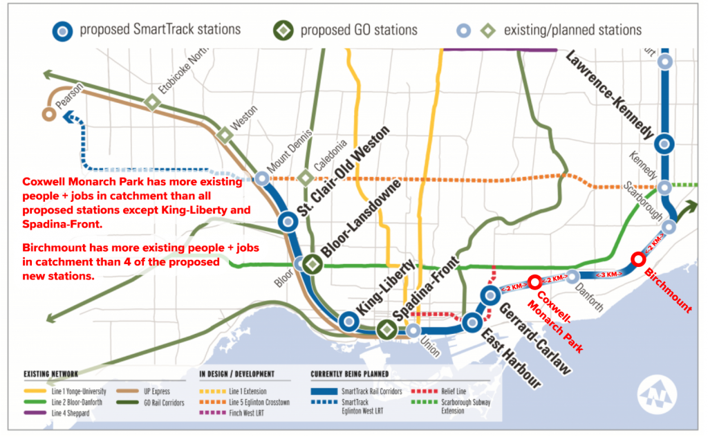
The primary selling point of the SmartTrack plan is that frequent, somewhat-subway-like service on an existing above-ground corridor at a TTC fare could deliver some relief to the overloaded core of Toronto’s subway system far sooner than the never-today/always-tomorrow Relief Line subway can be built (let alone funded). Yet, for reasons that seem not to exist in any available documentation, the area of the proposed SmartTrack route with the greatest potential to deliver that relief to the subway is being left with the longest gaps between stations.

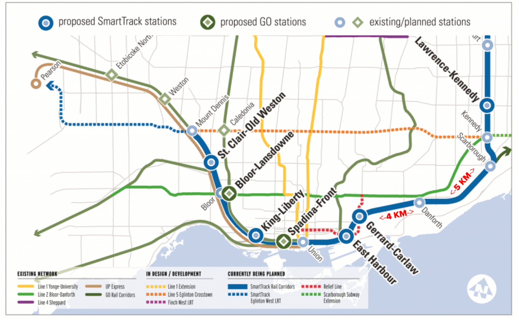
While much of the ST route calls for two-kilometre station spacing, it’s a full four kilometres from the proposed station at Gerrard Square (where SmartTrack might eventually connect with the proposed relief subway line) to the next station east, GO Danforth. (And the next station heading east from GO Danforth is another five kilometres.) The subject came up over dinner with some transit-planner friends a couple of years ago and it was agreed that Coxwell Avenue, roughly 2 km from both GO Danforth and the proposed Gerrard-Square station, seems to be an ideal location for addressing this void. Little did some of us realize that upon looking at the situation more closely we would discover the case for a Coxwell-Monarch Park SmartTrack stop was much stronger than the cases for nearly all of the approved ST and RER stations.


Can something as big as a railway station fall through the cracks?

A few months after that dinner, in August 2016, Metrolinx contacted the Danforth East Community Association about setting up a meeting with community members regarding plans for upgrades to the GO corridor (the southern boundary of DECA’s area). The meeting with DECA’s visioning committee (which I co-chair) took place on Sept. 13, 2016, in the basement of Gerrard Pizza (near Danforth and Coxwell). As expected, area residents raised concerns about noise associated with increased train frequency. And some wanted to know why we were already having to add a fourth track when “it seems like only yesterday” that GO was keeping them up all night with construction to add a third track (it was actually about a decade ago). One woman added: “Why couldn’t they get it right the first time?” (As we’ll see toward the end of this note, there are also valid reasons to question the commitment to getting this bit of the Lakeshore East corridor upgrades right the second time.)

Some meeting attendees, sick of crowding and unreliable service on the TTC, also had some “what’s in it for us?” questions. Possibly seeing an opportunity to deliver good news, the man leading the three-person Metrolinx entourage, eagerly mentioned the proposed Gerrard Square station. He and the other Metrolinx staffers appeared quite surprised when it was pointed out that a station at Gerrard Square – like the TTC’s relief-subway proposal – would be too far west to do much for people who already can’t rely on being able to squeeze into jammed subway trains at Woodbine, Coxwell, Greenwood and Donlands in the a.m. rush.

When asked about the possibility of an ST station at Coxwell, the lead Metrolinx representative replied that he was certain the site had been studied using “strict criteria” and that the idea must have been rejected by experts.

I then asked him to provide me with the reports from that study process, particularly with regard to Coxwell-Monarch Park or a station in the long no-man’s land between Gerrard Square and GO Danforth. He said he would be happy to send me the details and that I should email him a reminder. Thus began a long back and forth for which Metrolinx – nearly two years later – remains unable to provide any such documentation, detailed or otherwise.


What Metrolinx was able to tell us

Anyone who has studied Metrolinx’s many official online reports regarding RER, SmartTrack and the station-selection processes will have read repeatedly that “An initial identification of over 120 potential station sites was narrowed to 56 (it’s 50 in some reports) with supportive infrastructure through a high-level evaluation of transport connectivity, planning and land use and technical feasibility.” Coxwell was listed as a potential station on an initial Metrolinx compilation of 120 potential stops. Coxwell was also under consideration after the list had been winnowed to 50 (or 56, depending the document). At some point after that, but before the initial business case studies began, Coxwell disappears from the list. That’s about the extent of it … unless you consider what I was told by one former Metrolinx staffer (who had yet to leave when the cut-down process and/or any early-stage studies would have taken place), including:

  • I asked the same question of MX Planning [about criteria and results used for eliminating stations early on], as they engaged us in Economic Analysis shortly before they started stage 6 (the business cases) for the short list.  They didn’t do any modeling for the lists of 120 or 50 stations, the decision was subjective …
  • “Remember what [XXXX] said to me during my exit interview: ‘Let’s face it, everyone fabricates the evidence, the city does it, we do it. The new-stations process was always going to be political.’ ” 

The former staffer, as well as two current ones, also mentioned in recent years that even when Metrolinx got around to modeling business cases for the short list, some key criteria that were used were chosen with suburban commuter rail in mind and was thoroughly inappropriate for the urban areas to be served by SmartTrack. They’ve also pointed out that at least one of the technical feasibility rules regarding stations on curves was broken for stations that politicians in positions of power were demanding.

Meanwhile, two senior bureaucrats, one with the city and one formerly with the TTC, have told me that the only stations considered for SmartTrack and for study by Metrolinx were chosen – not through a rigorous professional process – but by advisers to the winning campaign in Toronto’s 2014 mayoral race. And while the current mayor’s office eventually gave in on an obvious flaw in the initial ST plan (the since-killed western spur under Eglinton), it seems apparent that no serious second thought was ever given to addressing potential flaws or better solutions in the SmartTrack plan for the old city’s east end and Scarborough.


The broad east-end transit context

My discussions in recent years with city staff regarding several issues (including the Danforth Avenue Planning Study, the Main Street Planning Study, two individual high-rise development plans for Main and Danforth, Metrolinx’s RER-ST corridor upgrades and SmartTrack itself) have often indicated that the official view from 60 Queen Street West is that the east end of the old city is very well served by transit, and that a relief subway (aimed primarily a dealing with dangerous and off-putting crowding on the Yonge subway and at Bloor-Yonge station) would solve any possible east-end concerns – even if the line comes only as far east as Pape.

And that received wisdom might seem valid if you don’t look much beyond simple maps. But a close look at long-term transit-usage trends in Planning District 6 (the four pre-2018 city wards abutting the Bloor-Danforth subway between Victoria Park and Broadview) indicates otherwise. Most of the key details on this point can be found in these two 2016 columns I wrote for the Beach Metro News:

(Though newer Transportation Tomorrow Survey data have been released since these columns were written, sources tell me there’s a strong chance the data are suspect (with only a 7-per-cent response rate), so I’m hesitant to put stock in the new numbers until a trusted transit data analyst I’ve worked with previously has a chance to seriously study them).


Five key points for understanding the east-end context include:

  1. PD6, despite being an inner-ring planning district that should be easy to serve by relatively low-cost transit for trips to the nearby downtown, has seen transit lose so much market share for such trips that, as of 2011, it had the lowest percentage of transit use for downtown a.m. peak trips of any Toronto/416 planning district (yes, that includes Scarborough, Etobicoke and North York). And, all the while, car usage was on the rise for downtown trips from PD6.
  2. PD6 is the second biggest generator of trips to the core of any GTHA planning district – it’s a market that really matters with major potential for major ridership gains without huge investments;
  3. Since the Scarborough Rapid Transit (SRT) line opened to Scarborough Town Centre in 1985, Bloor-Danforth subway trains have filled up east of PD6, while crowding at the Bloor-Yonge pinch-point becomes increasingly dangerous. And if the proposed multibillion-dollar Scarborough Subway Extension succeeds in attracting more riders to line, the problem will only get worse. A 2014 TTC report shows that the seven stations from Warden to Donlands, inclusive, have been losing ridership in the a.m. peak over the past 30 years, likely due to crowding that won’t be resolved even if a relief subway is ever built.
  4. Areas east of the Don River have only two trunk east-west streetcar lines between the lake and Danforth Avenue, unlike the areas further west, which have five, including major TTC routes on King, Dundas and Wellesley-Harbord (I’d add Queens Quay, but that’s not fair). Furthermore, the two lines that penetrate the east end, the Queen 501 and the 506 Carlton (which largely runs on Gerrard in the east end), have seen service cuts over the past three decades that have resulted in big ridership losses (without helping helping the TTC balance sheet). Because its bordered by the Don Valley on the west and north, PD6’s road connections to the rest of the city are also limited.
  5. GO trains roll through the east end (largely empty outside of the rush hours) without stopping in enough convenient places while charging uncompetitive transit fares. For many east enders, GO trains serve only to disrupt sleep or force conversation breaks when they roar past.

The narrow Coxwell-Monarch Park context

For me, a brisk walker, it’s 25 minutes on foot from the bridge that carries GO trains across Coxwell Avenue to both GO Danforth and the proposed SmartTrack station at Gerrard Square. Taking the TTC to those stations isn’t much faster, at least if my unscientifically small sampling counts for anything. My five weekday trips to or from GO Danforth took 19.5 minutes on average; three test trips to Gerrard and Carlaw averaged 20 minutes and 16 seconds – and, of course, once at those stations another separate fare would be required to travel farther. (Two of the four trips to GO Danforth included nine-minute walks to Coxwell subway station because the No. 22 bus was unable to pick me up before I got to the subway).

Despite talk of SmartTrack offering some relief, station location choices made by the Toronto mayor’s office seemed overly focused from the start on proximity to large development sites and not focused enough on pent-up demand (it was also weird that the initial ST plan would ignore existing need/low-hanging fruit in the mayor’s own city while putting terminal stations in Markham and Mississauga). Some of the errant focus appears to have been spurred by misguided advice that tax-increment financing would be a significant source of revenue for the SmartTrack project. And while politically connected developers aren’t likely to enrich themselves spectacularly in the Coxwell-Monarch Park catchment zone, ingredients essential to the any station’s success (criteria that were to be key in Metrolinx’s short-list screening process) are readily available, including the promise of growth and modest but near-guaranteed development.


Five reasons why Coxwell-Monarch Park is a great ST station location

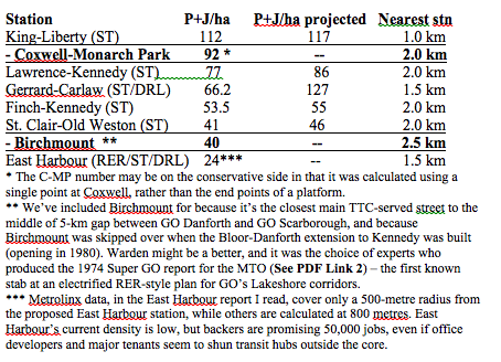
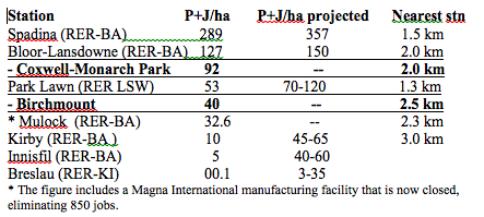
  1. The Coxwell-Monarch Park catchment zone provides real, existing people-and-jobs-per-hectare numbers that are better than five of the six new stations chosen for SmartTrack, with more growth in the works.


C-MP also fared well when compared with stations Metrolinx and/or politicians at Queen’s Park selected for RER.

The Coxwell-Monarch Park catchment zone’s

  • 16,385 residents total is more than in 37 of Metrolinx’s 51 mobility hubs;
  • 2,132 jobs are more than in nine of the 51 mobility hubs;
  • 18,517 residents and jobs combined, is 85% more than Metrolinx’s 2031 goal for a Gateway mobility hub.
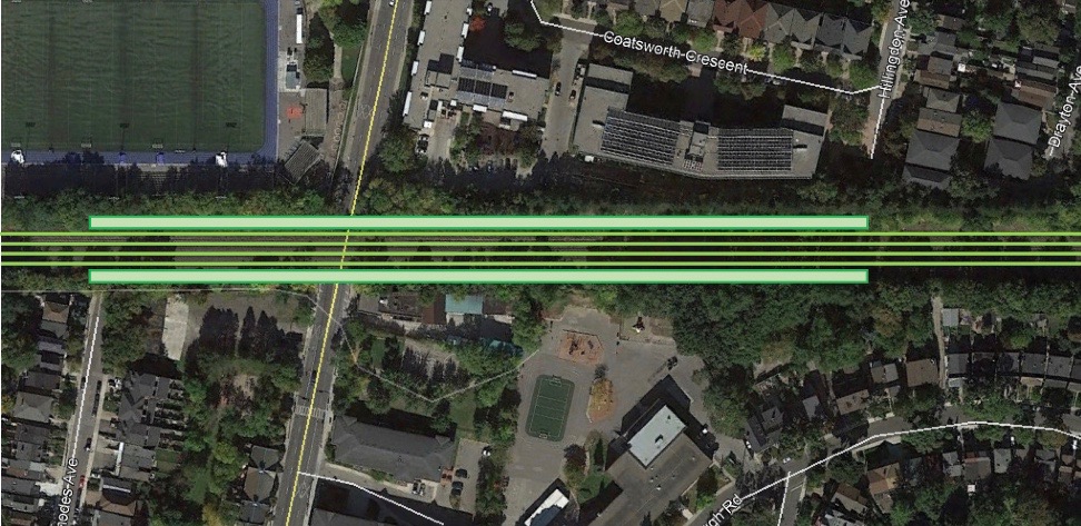
  1. The Coxwell-Monarch Park catchment zone provides development and growth potential. While no “P+H/ha projected” figure is provided for C-MP in the tables above, there is increasing mid-rise development pressures along Danforth Avenue, which prompted the recently completed Danforth Avenues Planning Study. A mid-rise co-op development is already in the works for Coxwell and Upper Gerrard. Also, plans for a second significant employment node on Coxwell Avenue, led by CreateTO, are in the works for the nearly five-acre TTC site at Danforth, including TTC offices, a mega-police station and community amenities. (The first Coxwell node is slightly north of the C-MP catchment zone, and includes 5,000-plus jobs between Michael Garron Hospital and the Toronto-East York Civic Centre). On both sides of Coxwell, directly south of where the station would be, there are two underutilized half-acre sites, depots for U-Haul and a building-materials retailer (and we’re told Ottawa is looking at ways to make it easier to develop such sites adjacent to railway tracks at stations on passenger-only rail lines). We should also add that large numbers of visitors to and from the sports dome and high school immediately northwest of the C-MP station site have caused enough traffic and parking headaches that a study was commissioned (even though it glossed over the need for transit improvements). The study, completed by WSP in July 2017, is here: http://www.tdsb.on.ca/Portals/ward15/docs/1610692701REPMonachPark09062017v12rsrs.pdf
  2. A Coxwell-Monarch Park station would address social equity concerns. There’s a significant amount of nearby assisted-living projects, including – right next to where the station would go – Toronto Community Housing buildings and seniors homes on Coatsworth Crescent and Amik Plaza’s residences for Indigenous Canadians. (Amik Plaza is operated by Wigwamen, which has other residences in the C-MP catchment zone http://www.wigwamen.com/housing/locations/ and has most of its properties in the east end). Wigwamen has written letter in support of a C-MP station. Further away, but still within the pedestrian catchment zone is Tobias House at Danforth, and there are more seniors buildings just west of Monarch Park. We’re talking about lots of low-income people who tend to be transit “captives.”
  3. A Coxwell-Monarch Park station is sited well for transit connectivity: Especially if SmartTrack offers service at TTC fares with TTC transferability, this would be a solid location from Day 1 with good long-term growth potential. At present, the two bus routes that serve Coxwell Avenue handle 55% more riders than the entire Oakville Transit system*. There’s a case for combining the two routes to provide one-seat service all the way from the Beach area, via this proposed ST station and Coxwell subway station, through the hospital/civic centre employment node and all the way up to Eglinton. The case gets stronger as of 2021 when this combined route can eventually link the Eglinton-Crosstown with the Line 2 subway at Coxwell and SmartTrack, likely the only spot in the east end where one bus route could join all three of those key rapid-transit lines.  *Using 2015 data, Oakville Transit carried 2.83 million riders a year. The two TTC routes serving Coxwell (Nos. 22 and 70), handle 14,300 riders on an average weekday, which the TTC multiplies by 306 to get an annual figure, in this case, 4.38 million.
  4. Coxwell-Monarch Park was chosen by experts for the Super GO electrification plan – and that report was produced by transportation professionals – its station-location choices were based on study, not political priorities.

In summary

We have a new provincial government and new ministers of Environment and Transportation, both of whom are people who should see the need to restore the public’s faith in transportation-planning processes. Ontario’s competitiveness and sustainability hinge to a significant degree on regaining a trust damaged by politicians at all levels who interfered with the public service’s ability to fearlessly prepare menus of options, objectively pull together and analyze evidence, and use their professional expertise to speak truth to power. The case of Coxwell-Monarch Park appears to be strong and appears to have fallen through the cracks because of flaws and corruptions in the process. While it would be inappropriate to ask for politicians to demand that this station be added to the SmartTrack project – despite the strong evidence – it’s a crucial matter of provincial interest (municipal and federal, too) that thorough study be done that a) examines the merits of this specific potential station and b) looks seriously at how it could possibly have been overlooked so we can learn from our mistakes and get better results from the processes in the future. And while the lack of a station at Coxwell-Monarch Park might not have a negative impact on a “constitutionally protected Aboriginal or treaty right,” as the criteria at this stage of the process word things, it’s clear that the process has failed people who need better transit and live in the immediate pedestrian catchment zone of this proposed station, including Aboriginal people of Toronto. 


Five quick supplementary points we should make in closing

  1. While SmartTrack has cost and time-frame advantages to offer in a city and metro area that is way behind in building transit infrastructure, it in no way obviates the need to get on with a major new rapid-transit line through Toronto’s core that does not add to the crowding at the Canada’s two busiest transit stations, Bloor-Yonge (415,000 daily platform movements) and Union (275,000). This new major line would most likely be the so-called relief line that has been talked about for more than a century and which has been the top priority of knowledgeable transit people on and off for 50 years. At best, we should be looking at SmartTrack as a plan for borrowing capacity that can temporarily be made available on Metrolinx’s surface corridors and at Union to address urgent needs, understanding that Metrolinx must deal with huge regional growth and will almost certainly need it back.
  2. We should be thinking long-term with regard to the corridor upgrades, looking to what its maximum capacity can be and planning to ensure we can scale up to achieve it at the best price. Metrolinx has been taking an incremental approach, adding a third track on LSE to Scarborough last decade and preparing to add a fourth now. While my sources are not unanimous on this, it would seem they think we should be looking at how we’re going to get to five tracks from Union to Scarborough if we end up with a not-unlikely runaway success akin to London Overground. One respected Metrolinx source says we can do all the local and express service we need with four tracks, while others (Metrolinx and outside), say a fifth track is almost certainly going to be needed sooner or later because the corridor has to serve Via, provide redundancy and anticipate demand growth, and that preparing for it now is better for taxpayers and the residents who have to endure construction in their neighbourhoods. It’s worth noting that the 1974 SuperGO electrification report was calling for five tracks Union to Scarborough.
  3. It’s time to get serious about making the vast swaths of asphalt surrounding outer GO stations into destinations for much more than parking. If we don’t give people many good reasons to be on outbound trains in the a.m., RER’s new operating costs are going to swamp its revenues. Some elements of MTRC’s land-plus-property business model is likely the route to take, allowing a Crown corporation to professionally manage a massive real estate portfolio and earn returns for Metrolinx on the public’s investments. Done right, we can defray transit capital costs while expediting operating efficiencies. These lands also need to be the top/only choices for new developments with a public interest such as universities, colleges, hospitals, casinos, etc.
  4. In the period leading up to the rollout of RER, it’s worth doing a pilot project whereby all transit trips that begin and end within any one GTA municipality have fares capped at that municipality’s single fare. Because it would allow GO and the various local transit agencies to start fully supporting each other, the potential ridership increases might offset the revenue losses to a greater degree than might be expected. We can gain valuable real-world information about the transportation market and how transit can work more efficiently. It should help us to do fare integration intelligently. It should also offer significant rewards at a low risk because, as a pilot, it would have a termination date, if necessary.
  5. Though I’ve focused on Coxwell, the City of Toronto would be wise to look at how the Birchmount area can be developed. It’s numbers are decent, and it’s an area not at all well-served by transit at present. There are also huge underutilized sites. An ST station there (or near Warden and Danforth as proposed in the 1974 SuperGO report) could be a useful catalyst.


Notes on the contexts for some of the proposed new ST and RER stations

Lawrence-Kennedy is in PD 13, the eighth-biggest market for trips to PD1 (downtown). Transit already has a 75% market share of the trips to PD1, with 11% of the trips being made on GO. The station’s importance rests to a significant degree on the fact the Scarborough Subway Extension plan does not include a station at Lawrence, connecting with Lawrence bus. Prospects for creating new transit riders for trips to PD1 appear limited, though the station has been approved for ST even if the broken out business case has been questioned and was rated “low performing”.

Finch-Kennedy is in PD 16, the ninth-biggest market for trips to PD1. Transit already has a 79% market share, with 16% of trips made on GO. Prospects for creating new transit riders for trips to PD1 are  limited in the short term, though Milliken Square Mall and a Public Storage facility present lots of longer-term development land. The station has been approved even if the broken-out business case has been questioned (costs outweigh benefits).

Coxwell-Monarch Park is in PD6, Toronto’s second-biggest market for trips to PD1 (downtown), though transit has only a 52% market share – the lowest of all Toronto planning districts. Less than 0.5% the trips to PD1 are made using GO’s corridor, which runs PD6’s full length. PD6 generates 19% more PD1 trips than PDs 13 and 16 combined, while transit in PD6 has a 31% lower market share of PD1 trips. Not building a station leaves a 4-km gap in an area where SmartTrack may have its best potential to relieve Line 1 and Line 2 crowding. With a 700-metre extension of the TTC’s No. 70 bus, C-MP would connect directly with two routes that carry 55% more daily riders than the entire Oakville Transit system and would link C-MP with an employment hub (5,000+ jobs) at Michael Garron Hospital/East York Civic Centre. This C-MP station would also be 300 metres from a stop on the 506 Carlton streetcar, which carries 40k riders daily. C-MP should score well on Social Inclusivity and Accessibility, having a large TCHC development immediately to the northeast and assisted housing to the immediate south. The site has several development sites within its 800-metre radius area, including Danforth Garage, a.k.a. Coxwell Barns (five acres at Danforth currently undergoing a master-planning process under the aegis of CreateTO), a new building approved at Upper Gerrard and Coxwell, a 0.6-acre site next to station being used for U-Haul vehicle storage and a 0.5-acre building materials site where station entrance would be. How C-MP missed the list of 50 stations that qualified for IBC screening, let alone the short list, is a mystery (even to some Metrolinx staffers who cannot speak on the record). With high current density, travel patterns and low transit-market-share penetration, prospects for creating new transit ridership for trips to PD1 and helping relief effort appear to be very strong at C-MP station.

Birchmount is on the PD13-PD14 boundary. PD13 is the seventh largest generator of trips to PD1 and transit captures 75% of them, in part because it contains Kennedy station, probably the GTA’s second best transit-served hub. PD14 is the 11th biggest generator of trips to downtown, so the market is smaller than average. But there is considerable room for growth as transit captures only 55% of the market share for PD1 trips (third lowest of all PDs), and 30% of the transit trips to PD1 are by GO. Current density in the 800-metre radius is fairly low (but greater than nine of Metrolinx’s 51 mobility hubs). There’s lots of nearby developable and underutilized land, though much of it is exclusively “employment” meaning it would be a challenge to create the mixed-use urbanism in the short term. Birchmount is also within 800 metres of a Neighbourhood Improvement Area, one of the criteria Toronto wanted considered for ST consideration. Prospects for creating new transit ridership are moderate short term, but the potential could be big with zoning changes that allow for development of the Birchmount strip between Danforth Avenue and Danforth Road. Not having a station here leaves 5-km station gap, far too long for connectivity in an area that has transit needs. PD14, in particular, is starved for transit to PD1

St. Clair-Old Weston is in PD3, the fifth-biggest market for trips to PD1. Transit has a 62% market share, but less than 0.5% of trips made on GO. Site borders on huge amounts of former stockyards lands that have been converted to car-dependent big-box retail. Despite current low density, prospects for creating new transit riders for trips to PD1 appear good short term due to apparently unsatisfied demand in PD3. The developable Stockyards land (RioCan property) would require major rezoning and total urbanizing, something that could be done, though our record on such initiatives in Toronto is poor.

Park Lawn is in PD7, the 11th-biggest of 15 markets for trips to PD1. Transit has a 59% market share, and 35% of the trips are made on GO. People-plus-jobs density is not high, at least using the 2011 data that’s referred to in Metrolinx’s reports. But residential density will likely continue to grow considerably for a few years. There are concerns a new station would cannibalize ridership at Mimico and that a replacement of Mimico (especially after recent investments in Mimico station) would be a waste. The closeness of the stations should not be a major concern in that 1-km station spacing (along with flat and transferable TTC fares) may eventually prove to be essential to getting SmartTrack to its full potential. Prospects for creating new ridership for trips to PD1 look moderate, but they’re probably very good long term. The proximity of Mimico station and the lack of office-employment prospects on the old Christie bakery site would seem to indicate there there’s no rush to build this station. Trying to track down 2016 census data because things are changing fast.

Mulock In 2011, the population and employment density within 800 m of the potential Mulock station was estimated to be 32.6 people and jobs per hectare (P+J/ha). The job figures would have included the Magna facility, which is now closed, eliminating 850 jobs. There are two active development applications located within proximity of the potential Mulock station, both of which are minor in nature and do not represent a significant increase in density or change in land use: A new Shoppers Drug Mart store proposed for the northeast corner of Yonge Street and Savage Road; and 28 townhouses proposed on Silken Laumann Road.

Breslau This station was deemed to be high performing in Metrolinx’s rankings, but this report raises questions about how it could possibly have achieved such a label.

http://www.metrolinx.com/en/regionalplanning/newstations/IBC_Breslau_EN.pdf

The report says on page 14: “In 2011, the population and employment density within 800m of the potential Breslau station is estimated to be 0.1 people and jobs per hectare (P+J/ha). The lands surrounding the potential station are currently rural/agricultural and contain only a few houses, a church and a few businesses. Figure 4-1 illustrates the current land use permissions for the proposed station site and surrounding area. In 2006, an estimated 72 residents and 43 jobs were located within 800 metres of the potential Breslau Station. Projections from the Ministry of Transportation Greater Golden Horseshoe Model suggest that by 2031 the population and employment within the Station area may reach 334 and 209 respectively. [1] However, recent changes to policy and planning objectives have resulted in substantially higher population and employment forecasts for the Breslau area. Figure 4-2 shows where recent development has occurred and where development is anticipated within the Secondary Plan Area. The Draft Plan of Subdivision submitted to the Township by Thomasfield Homes shows that in addition to a new GO station, the following will be accommodated on its 94.9 net developable ha of land: 2,535 people; and 2,830 jobs (i.e. 24.6 acres Employment Land (2,450 jobs), 3.7 acres Commercial (116 jobs), 4.9 acres Mixed-Use Commercial (153 jobs) and 3 acres Institutional (40 jobs).” … “Given that the potential Breslau station is located within an undeveloped area, there are no ‘soft sites’ within 800 m of the potential station. Soft sites are considered to be parcels with a relatively high potential for change, such as parking lots and under-utilized sites given current zoning and the Official Plan designations. A new residential subdivision is being completed approximately one km east of the potential station site and considerable new development is underway or planned elsewhere within the Township and the larger Region of Waterloo.

https://observerxtra.com/2016/11/24/omb-upholds-woolwichs-staging-plan-breslau-subdivision/ Breslau plans would bring 6,710 people + jobs to the catchment, roughly 31 per hectare. Strangely promotional language in a Metrolinx document about Waterloo’s connections with Toronto. http://www.metrolinx.com/en/greaterregion/regions/waterloo-wellington.aspx

Innisfil This station is also deemed to be high performing, apparently based on some longer-term projects. From Page 13 of this report

http://www.metrolinx.com/en/regionalplanning/newstations/IBC_Innisfil_EN.pdf

“The existing population and employment density within 800 metres (m) of the potential Innisfil station is estimated to be 5 people and jobs per hectare (P+J/ha). While currently the area does not meet Metrolinx Mobility Hub. Guidelines for rapid transit, significant population and employment growth is anticipated for the South Alcona area. The draft Secondary Plan, which is under appeal, shows a Phase 1 population of 7,200 people and 1,100 jobs. Growth projections for Phase 2 will be subject to each five-year review of the Town’s Official Plan in the future. Figure 4-1 illustrates the land designations from the draft South Alcona Secondary Plan. Surrounding lands are largely designated ‘Agricultural Area’ and will not contribute to the local area density. When fully built, the South Alcona area is intended to have an overall gross density of 67 P+J/ha. Some of the proposed medium density and commercial areas are slightly outside the 800 m station radius. Assuming full buildout future densities within 800 m of the Innisfil station would be 40 to 60 P+J/ha.
Categories
Toronto Transit Uncategorized Urbanism

My 2013 submissions to Metrolinx and Toronto’s “feeling congested” process

FEEDBACK PROVIDED IN 2013 FOR:

– Toronto Planning’s “Feeling Congested” initiative (or why I circled only four of the 14 suggested funding tools instead of the requested five)

– Metrolinx’s Big Move funding options

ABOUT ME: Journalist and urbanist who worked nearly 40 years at four Toronto newspapers, mostly as an editor. I’ve written many times on transit matters and have frequently interviewed local and international transit officials and academics. I’ve followed local transit and development issues seriously since the 1960s and have recently been a commercial real estate reporter. I provided detailed (and, as it turns out, somewhat prescient) feedback on the Official Plan nearly a decade ago. I also provided a detailed critique of the Metrolinx’s Green and White papers, which appears to have been ignored.

Dear Feedback reviewers:

I’ve little to add regarding most of the Metrolinx and City consultation processes. Property tax increases and regional parking, gas and sales taxes will be needed for much of the revenue-gathering process. I’m eager to pay my share. But I have a few key concerns, mostly about our apparent unwillingness to even start looking seriously at the full economic potential of linking transit and land use through real world real estate leverage. Get that stuff right, and you’ll have a much easier time persuading the public to pay taxes and tolls, and our transit systems’ operations sides will be that much more effective day-in, day-out. 

TOLLS AND CONGESTION CHARGES:

It’s nice to see that talk of tolls and congestion charges hasn’t been as divisive and controversial as many had predicted, though that might change once politicians have to debate recommendations. Unfortunately, tolls and/or congestion charges likely won’t be very useful to us until we have enough transit-based alternatives for those living and/or working in largely car-dependent environments, and until we stop adding new sprawl in the region. As it stands, the TTC is overcrowded. Also, as ex-Transport for London vice-chair Dave Wetzel told me in 2006, that city’s congestion zone was much more effective in shaping behaviour than raising funds (He called the actual congestion revenue “a drop in the bucket.”) He also doubted the overall program would have worked without London’s massive rail networks, something we lack.

MENU OF REVENUE TOOLS:

It was also encouraging, at least from media coverage I’ve seen, that there’s fairly broad support for a fairly wide range of revenue tools. We’ve long talked about transit as an investment, but have still tended to act as if it’s an expense. We get hung up on initial outlay costs and don’t seem to pay any real attention to return-on-investment opportunities. Wise investors diversify the portfolio and we’d be wise to diversify the income sources. But the real key to investing is to focus on ROI. In recent decades, we’ve fallen down in this area, and it seems the revenue-tools discussion has ignored the need to nurture self-regenerating income sources.

BEWARE OF UNINTENDED CONSEQUENCES:

Reliance on development charges, “benefit assessment districts” and value-capture levies can be tempting and might seem fair on first thought. Unfortunately, if we’re serious about properly linking land-use and transportation planning (and we’d better be), we have to be wary of disincentives to growth in the station catchment areas. We have a longstanding and serious problem in the GTHA with perverse subsidies that inadvertently encourage the same sprawl that public policymakers are grappling with. So many accepted norms of the past century, including our property tax system, need to be re-examined if we want to direct growth to locations where it’s desired. This process has to focus not only on raising the bucks needed to fund transit expansion, but also on finding ways to give the public the best bang for their bucks. Often that won’t mean simplistic short-term strategies such as merely choosing less-expensive transportation technologies (though LRT will almost certainly turn out to be best tool for many priority applications we’ve identified).

LAND USE, TRANSIT PLANNING AND REAL ESTATE:

Somewhere in a space between the loons and hucksters who tell us we can have subways for free and the extremists who seem eager to silence any discussions about involving private-sector developers in transit capital projects, lies a significant funding tool largely ignored and/or forgotten on this continent.

      From what I can see, neither the city nor Metrolinx have given the Rail + Property directed-value-capture model (or Rail + Property value-trade) any thought while compiling their lists of potential tools, though in one-on-one discussions, I get the sense a few senior people in these parts know it’s out there. It may be that in the wake of fantastical recent claims from the Toronto mayor’s office (and problems 20 to 25 years ago involving Canada Square, Penta Stolp and early plans for Mel Lastman’s Sheppard subway), that directed value capture (not to be confused in any way with the value-capture levy mentioned in the city’s “Feeling Congested” documentation) is still seen as potentially more controversial than tolls and congestion charges. The thing is, we’re not just decades behind on building transit infrastructure, we’re way overdue for a discussion of how to fully unlock the potential of real estate development in contributing to the process.

     Directed value capture was an essential part of the business model in the Far Past, before the public took over transit operations, back when private operators had a fiduciary duty to approach all spending as proper and necessary investments. Duties to investors and shareholders forced private transit operators to be directly involved in the development of properties along their tramlines, often as amusement parks, main street commercial strips and residential subdivisions. They needed to capture much of the value they created for capital and operating investment returns, and they couldn’t wait passively for the process to start playing itself out.

     Directed value capture was also crucial to the success of Japanese railway companies beginning in the 1920s, led by Tokyu and Hankyu. Not only did they create profitable real estate-transit relationships in dense cities, they created many new towns involving rapid transit and all forms of real estate. That latter point is essential to understand because so much of the GTHA is suburban in form, rather than truly urban (and decades after establishment, even our older suburbs are not really urbanizing).

     And directed value capture, inspired in large part by the Japanese models, is the heart of Hong Kong MTR Corp.’s Rail + Property business model, which has made both transit-system construction and transit operations profitable since the 1970s, largely because MTR is also a major property developer. MTR was 100% publicly owned until 2000, when it became 23% publicly traded. It’s a strong performer on the Hang Seng Index and is now expanding by exporting its expertise (Melbourne, London and Stockholm). The Rail + Property model is also essential to ambitious current transit expansion plans in Paris.

      Yes, we fully realize Hong Kong is far denser than Toronto, and that government entities there have far more leeway to do as they please, and that Hong Kong has a very different property ownership regime – points usually trotted out by North Americans determined to shut down any such conversation and revert to simpler but much-tougher-to-sustain tax-and-toll revenue collection tools. But there are significant lessons we can learn from the MTR experience as well as tools we can adapt for the Ontario-specific context. If we get them right we not only raise significant funds for transit capital projects, but we improve operational efficiencies and provide the working tools for the transit and land-use planners who’ve awakened in recent decades to the mutually-supportive nature of their missions. Even better, if we prove to the electorate that we’re doing a really good job of fully leveraging the worth of our transit entities’ real estate assets, we’ll have a much easier time persuading the citizenry to cough up a bit more with the traditional revenue tools in the current discussion.

    How much could a directed value-capture program raise? The only truthful answer within the North American context is, who knows? As Martin Wachs, a long-distinguished California-based planning professor and expert on transit funding puts it: “This form of public-private partnership is not even in the lexicon. I don’t know about Canada, but in the U.S., imitation plays an essential role and until there is a proven example here, few people will take it seriously.” Wachs tells an interesting tale of one attempt to get such a plan rolling for the 1924 L.A. subway plan, but in the wake of the then-recent Russian Revolution, public involvement in land development was shot down as a communist idea. One of Wachs’s former PhD students, Prof. Robert Cervero of UC Berkeley has written extensively on the Far East models, and we should bring him to Toronto to talk about MTR. Robert and I are playing telephone tag right now.

   By some measures and accounts, Hong Kong does get its subways for free (though straight construction-outlay costs are similar to ours on a per-kilometre basis) and three extensions are currently approved or under construction (also, unlike Toronto, Hong Kong and London, for that matter, don’t tunnel in low-density areas). In a 2004 discussion with an MTR executive, interviewed for a Globe and Mail story, I was told that in North America, it should be realistic to expect that we at least get our stations for free. The logic was that if we can’t even get that much return on a subway project, we’re putting the stations in the wrong places and/or the funding model is broken. Free stations on the Spadina-York extension, based on capturing and leveraging their development potential, would have saved about $860M, or about 33% of the up-front capital costs, not to mention significantly improving operating revenues from Day 1. Instead, we opted for standalone stations that stifle most of the value they create. But even if 33% is overstating the potential, and that’s likely in the initial stages, when we’d still be experimenting with the adaptations for Toronto (and getting the crucial oversight and moral-hazard puzzles worked out), significant potential exists.

      Oversimplified, of course, Rail + Property directed value capture requires that the development goals and real estate potential be fully considered right from the start of the planning process. If we wait to consider station development and then try to collect levies or air rights or increased tax-base benefits that might accrue over time from the catchment area of an operating station, the public collects far less than it should and has to wait a long time to capture the value. Several decades-old TTC stations serve as unpleasant exhibits of what can happen, especially when you expand urban transit tools into suburban areas without a real plan. It’s important to note that Japanese railcos and DC’s WMATA have found that the serious development premium opportunities drop off dramatically after about 100 metres of the turnstiles. 

     Hugely important for us in considering Toronto-model possibilities, is the MTR view that it’s impossible to fully leverage crucial space potential atop operating stations if planning for significant development wasn’t included right from the conceptual stages of the station project. Tunnels and tracks are always expensive, but stations can be gold mines if you do them properly. And stations can and should have great catalyst effects for entire catchment areas, both financially and in the creation of vibrant urbanism. Essential to the exploitable efficiencies is the sharing of excavation and foundation costs. Next time you walk past a condo or office tower construction site, linger a while to take in the scale of the below-ground work. Then consider this MTR logic, that the marginal costs of adding a station (fully up to standards set and enforced by public sector experts) should be far less than the premiums available to landlords (private or public) whose commercial and residential tenants or condo holders can walk to platforms or other daily primary uses without ever having to go outside. Various land-tenure arrangements should be workable, and some flexibility might be needed, depending on needs of partners and the context of the site over time. MTR isn’t always eliciting presale/prelease interest from developers, but its stations are built to underpin development from the start, and they’ve found that in some parts of the market cycle it’s a good investment to sit on such sites for a few years. It’s a forward-thinking investment strategy that brings great returns to the public, but requires considerable private sector input and expertise.

      Part of the reason we can never get anywhere close to matching MTR’s return levels is that we have to factor in land-acquisition costs. However, we have huge swaths of strategically placed, publicly owned land that is significantly underleveraged (not just in the hands of our transportation authorities). At least one stretch of land would holds remarkable potential for a project that should be on the radar for the TTC and Metrolinx (a variation on it was yanked from the Chong report last year, at the last minute, just before it was leaked to the Star). We often talk of selling off public land, but it’s a much better deal for all concerned if we first try to leverage its full potential worth. Selling it off is akin to burning the furniture to heat the family home.

     I could go on, but won’t … for now.

A COUPLE OF CLOSING POINTS:

       Something akin to a REIT or real estate investment trust, may be needed to ensure Metrolinx’s land holdings are properly leveraged. Metrolinx faces a tricky balancing act, keeping the stations as connected as possible with current car-dependent suburbs, but shepherding a difficult transition toward transit-friendly urbanism. Obviously, serious thought is going into the process through Mobility Hubs planning for the station catchment zones, and my sources throughout the world of commercial real estate indicate that discussions are active throughout the region. But, Metrolinx has huge untapped outbound morning-rush GO capacity that will be needed soon because we can’t build new GTHA-wide transit capacity fast enough for the impending growth, especially after at least three decades of neglect. We need to make GO stations, whenever possible, into the centres of all-day destinations, places that local transit systems have to serve well, further reducing the need for parking at the stations.

       We have lots of existing public properties within Toronto that have potential but cannot be leveraged well because Build Toronto can only get access to them if the TTC or the city deems them surplus. We have to rethink and tweak this relationship.


Good luck. This mission is crucial to Toronto’s survival.

Steve

Categories
Toronto Transit Uncategorized

A Toronto Star editorial for the ages (and a few footnotes for context)

Interrupting a good read to study footnotes, according to Noel Coward, is like “going downstairs to answer the door while in the midst of making love.” Coward, the 20th-century wit, playwright and man about town was right, of course, but this is an occasion when the footnotes should be worth your while, especially if you’re the least bit interested in Toronto transit matters. But first, read this seemingly timeless gem from the Toronto Daily Star (faithfully retyped further below for better readability) .

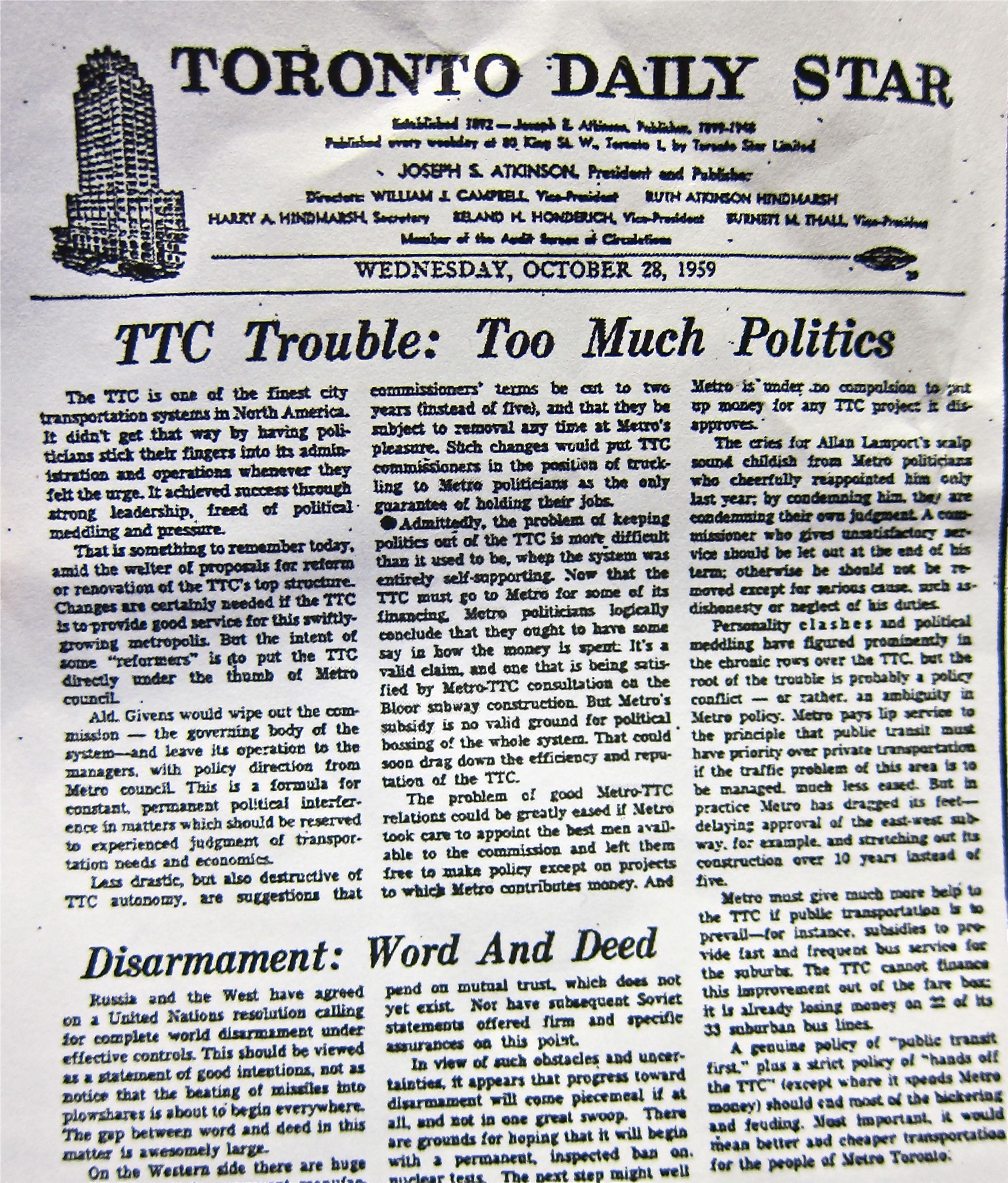
TTC Trouble: Too Much Politics (Toronto Star editorial from October 28, 1959)

The TTC is one of the finest transportation systems in North America. It didn’t get that way by having politicians stick their fingers into its administration and operations whenever they felt the urge. It achieved success through strong leadership, freed of political meddling and pressure.

That is something to remember today, amid the welter of proposals for reform or renovation of the TTC’s top structure. Changes are certainly needed if the TTC is to provide good service for this swiftly growing metropolis. But the intent of some “reformers” is to put the TTC directly under the thumb of Metro council.

Alderman Givens (1) would wipe out the commission — the governing body of the system — and leave its operation to the managers, with policy direction from Metro council. This is a formula for constant, permanent political interference in matters which should be reserved to experienced judgment of transportation needs and economics.

Less drastic, but also destructive of TTC autonomy, are suggestions that commissioners’ terms be cut to two years (instead of five), and that they be subject to removal any time at Metro’s pleasure. Such changes would put TTC commissioners in the position of truckling to Metro politicians as the only guarantee of holding their jobs.

Admittedly, the problem of keeping politics out of the TTC is more difficult than it used to be when the system was entirely self-supporting (2). Now that the TTC must go to Metro for some of its financing, Metro politicians logically conclude that they ought to have some say in how the money is spent. It’s a valid claim, and one that is being satisfied by Metro-TTC consultation on the Bloor subway construction. But Metro’s subsidy is no valid ground for political bossing of the whole system. That could soon drag down the efficiency and reputation of the TTC. (3)

The problem of good Metro-TTC relations could be greatly eased if Metro took care to appoint the best men available to the commission and left them free to make policy except on projects to which Metro contributes money. And Metro is under no compulsion to put up money for any TTC project it disapproves.

The cries for Allan Lamport’s (4) scalp sound childish from Metro politicians who cheerfully reappointed him only last year; by condemning him, they are only condemning their own judgment. A commissioner who gives unsatisfactory service should be let out at the end of his term; otherwise he should not be removed except for serious cause, such as dishonesty or neglect of his duties.

Personality clashes and political meddling have figured prominently in the chronic rows over the TTC, but the root of the trouble is probably a policy conflict — or rather, an ambiguity in Metro policy. Metro pays lip service to the principle that public transit must have priority over private transportation if the traffic problem of this region is to be managed, much less eased. But in practice, Metro has dragged its feet — delaying approval of the east-west subway, for example, and stretching out its construction over 10 years instead of five. (5)

Metro must give much more help to the TTC is public transportation is to prevail — for instance, subsidies to provide fast and frequent bus service for the suburbs. The TTC cannot finance this improvement out of the fare box; it is already losing money on 22 of its 33 suburban bus lines. (6)

A genuine policy of “public transit first,” plus a strict policy of “hands off the TTC” (except where it needs Metro money) should end most of the bickering and feuding. Most important, it would mean better and cheaper transportation for the people of Metro Toronto.

The long-awaited footnotes

  1. Phil Givens would go on to become mayor, 1963-66. Maybe best remembered for his crusade to bring Henry Moore’s Archer to Nathan Phillips Square. Importantly, but less well known, he saw the future of Toronto’s transportation system as car-based and later became an MPP heavily supporting the Spadina Expressway.
  2. The TTC was still self-supporting for operations until the early 1970s, but there was concern in 1959 because, for the second time in its history, the TTC reported an operating loss ($96,755). The reference in the editorial is to the TTC’s need for funds from Metro (a now-defunct senior, regional municipal government akin to Peel, York Region or Durham) to build the University-Bloor-Danforth subway project, for which ground would be broken a couple of weeks after the editorial was published.
  3. Metro’s money was coming with dangerous strings attached, but the interference was minor compared with the damage Queen’s Park would eventually cause via vote buying, once it started subsidizing operations and capital in the 1970s. The height of interference came early in the 21st-century when provincial cabinet minister Greg Sorbara and federal finance minister Jim Flaherty made a deal to support each other’s pet projects, the wasteful and unnecessarily tunnelled York-Vaughan subway extension and the 407E-412-418 highway expansion in Durham Region.
  4. Allan Lamport (mayor 1951-55 and TTC chair 1955-59) is best remembered for Yogi Berra-like malapropisms (e.g.: “It’s hard to make predictions, especially about the
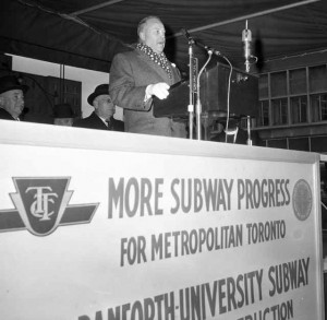
    TTC chair Allan Lamport, addresses the gathering on Nov. 16, 1959, when a smaller, poorer Toronto went ahead and broke ground on the University and Bloor-Danforth subway project, even though it got no funds from Queen’s Park or Ottawa.

    future,” and, “If anybody’s going to stab me in the back, I want to be there.”  He should be remembered most for battling to make transit and the TTC the top transportation priorities, a tough task in a town with rapidly rising car ownership, with Metro Chairman Fred (Big Daddy) Gardiner favouring expressways and in a province that would pay 50% of expressway costs but refused to subsidize subways or public transit.

  5. The University and Bloor-Danforth (Woodbine to Keele) got built in 75 months when the province guaranteed the TTC and Metro loans, allowing Metro politicians to vote to speed up construction. Building the east-west subway along Bloor made sense as part of a longer-term plan that included the Queen subway (roughly what we call the Downtown Relief Line). Within a decade, however, suburban Metro politicians and the owners of Yorkdale pushed instead to build a subway in the Spadina Expressway median instead. Sixty years later, politicians overrule serious planners and evidence, leaving us unable to built the elemental basis of a proper subway network.
  6. The most amazing thing about this statement is that it’s telling us 11 of the suburban bus routes were making a profit (largely because of the zone fare system). It should be noted that all of the inner-city zone routes were profitable on their single-zone fare, and were helping subsidize money-losing routes in the suburbs that were being rapidly expanded since the creation of Metro in 1954. Once operating subsidies became available from Metro and the province in the 1970s, zone fares were killed and the TTC threw out its most valuable asset — its business model. Deficits mushroomed to such a degree by the 1980s that the TTC has, for 30-plus years, been forced by politicians into a downward spiral of service cuts that have done nothing to improve the system’s financial sustainability.

Further reading for serious Toronto transit nerds

  • Seminal Lessons From the Transit Time Tunnel: (first published in the Toronto Star in February, 2015). It explains how we built the University and Bloor-Danforth lines, on budget and ahead of schedule with no funding help from Queen’s Park or Ottawa.
  • More on the sordid deal between Greg Sorbara and Jim Flaherty can be found in a chapter of Sorbara’s memoirs, The Battlefield of Ontario Politics, (Dundurn Press, 2015) summarized here by Star columnist Royson James. (Steven Del Duca’s game of largesse regarding unwarranted GO stations and a Highway 400 widening through his riding “to ease congestion” is peanuts by comparison.)
  • Edward J. Levy’s Rapid Transit in Toronto, A Century of Plans, Projects, Politics and Paralysis (2015, published by Neptis Foundation).


Categories
Toronto Transit Uncategorized

Have Gardiner gridlock fears been ramped to the max?

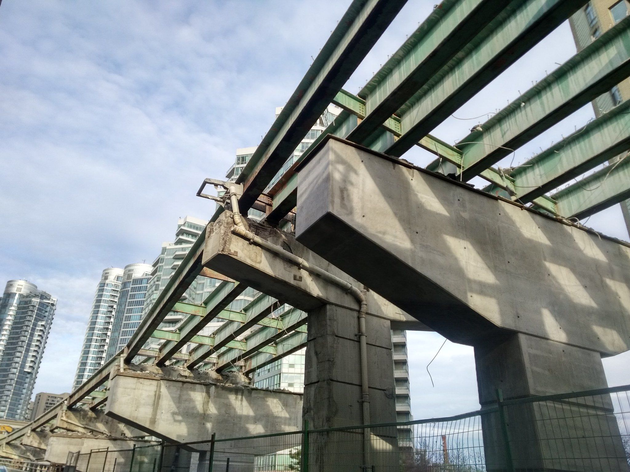
The York-Bay-Yonge ramp demolition is proceeding quickly. Peter Baugh photo
The York-Bay-Yonge ramp demolition is proceeding quickly. Peter Baugh photo @PWBaugh

By STEPHEN WICKENS

On Monday, eight days after the end of the world, a Toronto TV newscast was still making a fuss about the shutdown of a Gardiner Expressway ramp that had been, until April 16, funnelling 21,770-plus vehicles onto York, Bay and Yonge streets on average weekdays.

“Car-mageddon” forecasts began in earnest on Feb. 8, with Mayor John Tory making a stern, brows-knit announcement. “I’m not going to sugar-coat this,” he warned, conjuring memories of newsman Ted Baxter from the old Mary Tyler Moore Show.

In March, Wheels, the Toronto Star’s largely advertorial automotive section, published a rant under the headline “York-Bay-Yonge ramp demolition will equal traffic chaos for downtown Toronto.”

Then, in the final days before the Y-B-Y ramp closed, local media outlets revved up the coverage – lots of interviews with concerned and angry expressway users interspersed with bureaucrats explaining that the ramp is 50 years old and crumbling.

One official, apparently unaware that relatively few of Toronto’s downtown workers arrive on the eastbound Gardiner, said “we’ll all just have to bite the bullet.”

I hate sitting in traffic as much as the next guy, (part of the reason I rarely drag tons of steel, glass, rubber and plastic with me when I go downtown). I own a car and I’m sympathetic with co-workers made late by congestion. I very much appreciate that there’s a significant group of people whose livelihoods require they drive into and out of the core.

Yet for all the media coverage, I haven’t seen a story that puts into context the degree to which closing this two-part ramp will crimp the transportation network during the eight months needed to build the replacement exit at Simcoe (apologies if I missed it).

After a few emails, phone calls, a little Googling and some rummaging through the home-office filing system, I’d classify the ballyhooed ramp-gridlock-crisis story as much ado about relatively little. Rather than chaos, what I see is merely more evidence of just how self-defeating car-based transportation is as a major mode in an urban context.

City staff tell us 1,537 cars were using the old ramp in the busiest 60 minutes of the a.m. rush on an average weekday. That’s less than a quarter of the average number of people who emerge downtown from each of the TTC’s seven core subway stations (Dundas, Queen, King, Union, St. Andrew, Osgoode and St. Patrick). The seven-station peak hour total is 43,295 arrivals (28.2 times the ramp number) (1).

Over the three-hour a.m. rush, the Y-B-Y ramp sees roughly 4,500 vehicles (2), while each of the seven core stations averages 14,910 people. That’s 104,352 total, 23.2 times the ramp number.

Looking at the 24-hour period, the ramp’s 21,772 total is less than any of the seven aforementioned stations (even though the subway is shut for about four hours each night). The seven-station total is 412,472, or 18.9 times the ramp number.

Not including GO and Via, 6.9 times more people get off at Union station’s subway platforms in the a.m. peak hour than the number of cars passing through the ramp. In the 20 hours that the Union subway platforms are open, they handle 118,446 people, 5.4 times the number of vehicles using the ramp over 24 hours.

And none of this includes the roughly 89,000 who travel downtown by GO Transit on an average weekday (3), or the tens of thousands more who arrive by TTC surface routes, on bikes and on foot.

In fact, as urban planner Gil Meslin (@g_meslin) tweeted in response to this post: “That peak-hour ramp usage is less than the number of people disembarking from one full GO train at Union Station.” A GO train can carry 1,670 people.

(And we haven’t even mentioned the TTC’s two busiest stations, Bloor-Yonge and St. George, neither of which is really in the core. Bloor-Yonge, BTW, handles 18.3 times as many people a day as the Gardiner ramp and, by one measure, more daily passenger movements than all of Union Station and Pearson Airport combined).

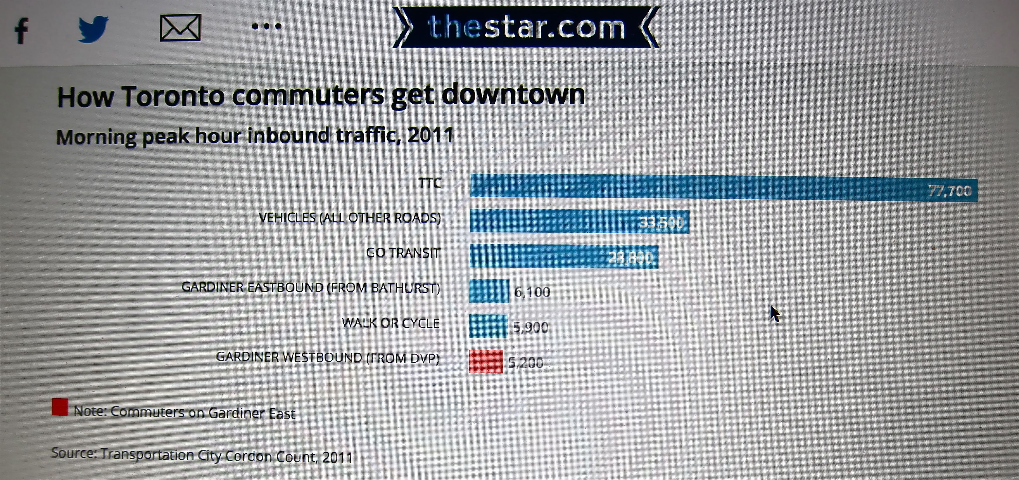
City data from 2011 measuring how people are getting downtown in the a.m. peak hour indicate that just 3.9 per cent are arriving on the eastbound Gardiner and the expressway as a whole is delivering just 7 per cent. Cyclists and pedestrians were at 3.2 per cent, and with the dual booms in condo construction and cycling those modes have likely since surpassed the eastbound Gardiner’s proportion of the total.

This Toronto Star graphic, produced during the debate on the fate of the eastern Gardiner, illustrates how little the expressway contributes to the core's connection to the region. The data are from 2011, so it's likely that with the dual condo and bike booms that the pedestrian and cyclist total has well eclipsed the Gardiner.
This Toronto Star graphic, produced using city data during the debate on the fate of the eastern Gardiner, illustrates just how little the expressway contributes to the core’s connection with the region. The peak-hour numbers are from 2011, so it’s likely that, with the dual booms in condo construction and bike usage, the pedestrian and cyclist total has well eclipsed the Gardiner.

Would media go this big if TTC had to temporarily shut a core subway station or GO was forced to remove a handful of train runs? Highly unlikely.

Over the decades, most of the city and its media have become inured to the core transit system’s overloading. Delays happen and people get mad but public transit is resilient. As long as we’re not totally shutting down what little subway infrastructure we have into Toronto’s core, we always muddle through.

So why the big deal over a single highway ramp?

Driving is so land-consumptive that you don’t need many cars to create serious congestion. Driving is also inefficient because it’s disrupted so easily, whether by regular volume, common fender-benders, basic maintenance and construction … or the occasional ramp shutdown.

And our media outlets, including many of the reporters and editors they employ, seem unable to see differences between the urban and suburban parts of the metro area, or even within the 416. Prevailing assumptions about the importance of cars to the older parts of the city, where so much of the economic engine resides, are wildly inaccurate.

We decry the billions of dollars that congestion is said to cause us, but through ignorance and cynical politics we continue to give priority to spending on a mode that guarantees congestion and inefficiency.

Thankfully, we don’t have room to widen roads in the city. But unfortunately, politicians – even conservatives who claim to be respectful of taxpayers – choose not to listen to facts or do the basic math when it comes to urban and suburban transportation issues.  And our media, especially broadcast outlets, don’t put much effort into helping to seriously inform the public.

The result is that, to ensure we don’t inconvenience a small number of vocal drivers who have the ear of media and politicians, we’ve allotted $3.6-billion for rebuilding and adjusting the alignment of a short stretch of the Gardiner Expressway, yet we somehow still have nothing for a decades-overdue subway line through the core that can benefit the city and the entire region on a scale few can comprehend.

NOTES

1. The numbers of people arriving by car are surely higher than the number of cars. I’ll factor that in and adjust the totals when the city provides it’s updated formula. I asked last week, but so far no luck. From my files, city staff acknowledged at a Canadian Urban Institute event in 2005, that it assumed cars on local expressways carry less than 1.2 people during the a.m. rush and slightly less than 1.1 for the rest of the day.

2. The city suggested I multiply by three the 1,537 a.m. peak number to get the full a.m. rush total. I’m reluctant to do that because the shoulder times outside the actual peak hour will necessarily be less. If, for example, I multiplied the TTC’s a.m. peak numbers by three, the totals for the seven core subway stations would jump considerably. I went with 4,500, which is also what The Globe’s Oliver Moore did on April 15 (page M3, but apparently not online).

3. GO buses, of course, use the expressway system, though they are a tiny part of GO’s Union customers. Vanessa Barrasa of Metrolinx told me that, “In anticipation of the Yonge-Bay-York ramp closure, GO bus made some minor adjustments for trips arriving from the west. We have not had any major delays caused by the closure.”


Categories
Toronto Transit Uncategorized

Crossrail versus TYSSE update

Black Creek station on the York-Spadina subway extension, slated to open in 2017, is an example of how suburban stations tend to be designed in the absence of a land value-capture regime.
Pioneer Village station on the York-Spadina subway extension, slated to open in 2017, is an example of how suburban stations tend to be designed in the absence of a land value-capture regime.

Late this year, Torontonians will be asked to celebrate the opening of the TTC’s 8.6-kilometre Line 1 extension from Downsview to Vaughan, the first bit of subway we’ve been able to accomplish in 15 years. The six-station Toronto-York-Spadina Subway Extension is very late and way over budget, with the latest calculations coming in at $3.2-billion, or $372-million per kilometre, despite traversing only low-density suburban areas.

Meanwhile in London, Crossrail — now officially named the Elizabeth Line — is also nearing completion. Granted, it had a six-month head start on the TYSSE, but it’s 118-kilometres long, nearly 14 times the TYSSE’s length.  The 40-station Elizabeth Line (also known to wags in London pubs as ‘The Lizard’) includes 22 kilometres of tunnels through the dense central city, but the project’s total cost comes to just $205-million (Canadian) per kilometre. That’s 55% of the per-kilometre cost we’re paying.

Let’s hope the people in charge of this controversial Scarborough subway project have finally learned their lessons. We don’t want to get burned again.

Stephen Wickens

Categories
East End Toronto Toronto Transit Uncategorized

No matter how much the TTC paid for the KPMG report, it paid too much

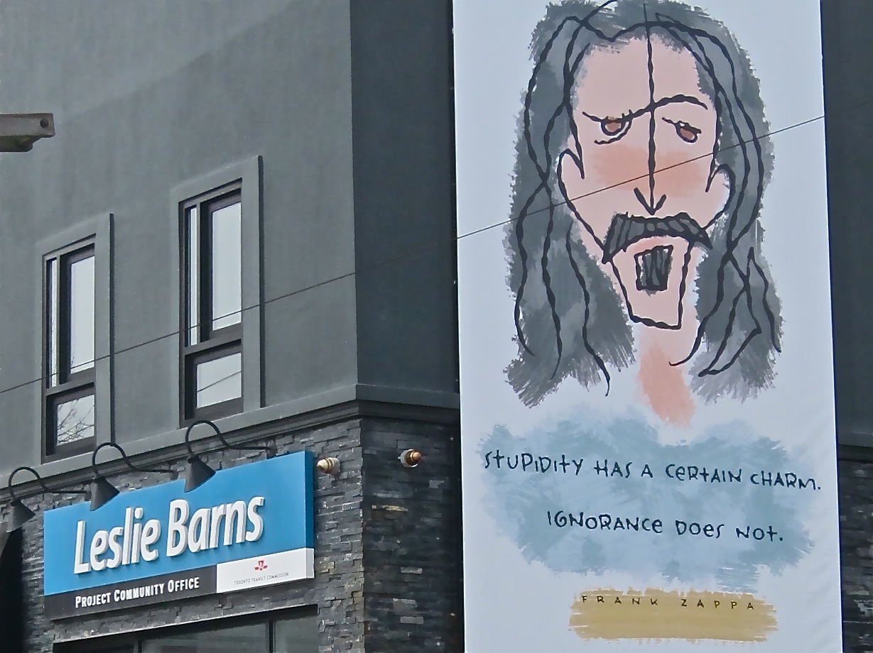
Don't know who put the Frank Zappa billboard up on the side of the building containing the Leslie Barns project office, but his words seem mighty appropriate.
Don’t know who put the Frank Zappa billboard up on the side of the building containing the Leslie Barns project office, but his words of wisdom seem mighty appropriate.

By STEPHEN WICKENS

The obvious irony is that a consultant’s report released in September 2016, advising the Toronto Transit Commission how to complete capital projects on budget and on time, missed its deadline by 10 months.

We don’t know if there was a set budget, and weeks of trying to find out merely how much the public paid has turned up nothing: The city told me to ask the TTC, while the TTC replied, sorry, “the city commissioned it.”

The consultant, KPMG, also didn’t respond to requests for comment on what it billed and why it took such a soft approach to investigating troubled projects – including the Toronto-York-Spadina subway extension (TYSSE), the Leslie Barns streetcar facility and new signalling systems for the Yonge-University-Spadina subway.

Apparently, the city seems happy with KPMG’s work and the TTC has agreed to adopt all 41 recommendations, including calls for “gate-keeping” at key stages on future projects, clearer definitions of management responsibilities and better processes for documenting and monitoring progress. Local media gave the report a quick and soft once-over, and likely won’t return to the matter.

But does this report get us any closer to delivering bang for the buck on transit projects?

A public angered by fiasco after fiasco on the transit capital file might ask why KPMG ignored the many people who warned early on that these projects were off the rails.

KPMG didn’t talk to David Gunn (the most-respected TTC chief in recent decades). Gunn, in 2011, told the TTC, politicians and Globe and Mail readers the signalling project was in deep trouble and that the grandiose, stand-alone stations on the TYSSE made no sense. He also advised TTC leaders to rethink the Bombardier streetcar purchase decision that has turned out to be so problematic.

In a recent discussion, Gunn pointed out that if the TTC had listened and opted for proven 70% low-floor vehicles instead, it would have saved money and grief and wouldn’t have needed the Leslie Barns maintenance facility at all. And if KPMG had talked to those who can say “I told you so” on Leslie Barns, it wouldn’t have swallowed the “scope creep” excuse for cost overruns (a botched site-selection process made the utility relocations necessary, setting off a chain reaction of cost escalations).

City councillor Mary-Margaret McMahon labelled Leslie Barns “a boondoggle” on her first day in office in 2010, but was repeatedly ignored by the TTC and fellow politicians. KPMG didn’t contact her either.

Seeking alternatives, McMahon assembled a group that included globally respected transportation engineer Ed Levy. If KPMG had spoken with him (or others in the group, including me) they might have learned the city – blinded by the prospect of getting 18 acres from the Toronto Port Authority for $1 – encouraged the TTC to skip international best practice’s Step 1 in picking sites for such facilities: minimize the deadheading or the number of unproductive kilometres. Toronto is now locked unnecessarily into an operating setup retaining wasteful commutes to get vehicles into and out of service, especially on the 509, 510, 511 and 512 routes.

Absurdly grandiose stations on the Toronto York Spadina Subway Extension were part of the reason the project is late and far more expensive than it should be. David Gunn warned us about the problem six years ago, but KPMG didn't bother to interview him.
Absurdly grandiose stations on the Toronto York Spadina Subway Extension were part of the reason the project is late and far more expensive than it should be. David Gunn warned us about the problem in 2011, but KPMG didn’t bother to interview him.

As for that too-good-to-be-true $1 site, a commercial real estate executive with the company then known as Barnicke told McMahon’s people the most it was worth – “if level, clean, approved and desirable for commercial redevelopment” – was $15-million. Cushman & Wakefield, the real estate consultants the Port Authority hired to assess the worth of the site put the value at $1, if it was left fallow for future parkland (trying to develop it would bring hugely costly liabilities into the equation).

In the end, the TTC paid more than 10 times the best-case $15-million price just to make the site usable. Connecting tracks alone cost 7.5 times the estimate the TTC used to justify the site choice.

KPMG states that costs escalated because of delays in awarding contracts; the hard truth is that costs soared because of haste to award contracts for an ill-conceived plan. There was a concerted effort to ignore informed people who were raising red flags.

On the TYSSE, some warned at the conceptual stage that it was nuts to push subway into Vaughan and bore deep tunnels through low-density areas. GO trains on the surface would have better served York Region’s rush-hour commuter rail needs. (You can read about the backroom politics that put the TYSSE into play in former provincial cabinet member Greg Sorbara’s memoirs).

So, how did KPMG investigate? It interviewed “68 key personnel and stakeholders at the City of Toronto, the TTC and from external organizations, including key personnel for each of the projects” – most, we can assume, are people with vested interests in minimizing the embarrassment that should accompany projects gone awry.

The report even includes a disclaimer that KPMG “neither warrants nor represents that the information contained in this document is accurate [or] complete.” (Imagine a newspaper that relies solely on the veracity of news releases and PR people?)

There’s some good (but blindingly obvious) advice in KPMG’s 200-plus-page report, but it ignores probably the most important truth: The world’s best project management cannot save bad projects.

Or, as Gunn put it: “There’s no magic to this stuff. You need a small, strong, informed group of managers, and the person at the top has to have the balls to stand up to politicians when they insist you do stupid stuff.”

Categories
The United Kingdom Travel writing Uncategorized

Edinburgh in February? It might be the best time to visit

The Scottish capital is a wonderful, walkable city that everyone should visit at least once, and if you abhor lineups or need a little space to yourself, you just might find that visiting in the off-season makes most sense. February was good.

About 2,000 visitors were expected on the gorgeous February day when I visited Edinburgh Castle. The thought of 10,000+ in peak season seems a tad scary.

By STEPHEN WICKENS, EDINBURGH

Zo Sasaki planned his return visit to Scotland’s capital for three decades, and in all that time he was certain of one thing: he would make the trip in the off-season.

Back in the mid-1980s, he and his wife, Mari, did a European tour in June for their honeymoon. “Almost perfect,” Mr. Sasaki told me as we ate ice cream on a gorgeous February day in Holyrood Park at the foot of Arthur’s Seat.

There was a lineup for ice cream, in February in Edinburgh's Holyrood Park at the foot of Arthur's Seat.
There was a lineup for ice cream, in February in Holyrood Park at the foot of Arthur’s Seat.

Yes, ice cream.

For while, there was even a lineup for the ice cream truck – in Edinburgh – in February.

“Such a beautiful city, lots to see,” the Tokyo resident said, “but last time Edinburgh Castle (was) way too crowded. Holyrood Palace? Closed. Queen Elizabeth (was) living there. Summer visit? I say wrong month.”

This time, the Sasakis visited both the landmarks anchoring the ends of the Royal Mile, which is central to the old town. Much to Mr. Sasaki’s surprise, even his climb to Arthur’s Seat (a small but special mountain overlooking Holyrood) was more pleasant in winter, thanks to calm and sunny weather.

“Last time, rainy, windy, cold – in June!”

Mr. Sasaki, a civil engineer, then told me something I’d never considered when planning my trip from Canada: Depending on location, February is the driest or second-least rainy month in Britain (something a little light Googling seems to confirm).

Add in the fact that flights and hotel rooms are cheaper in February – especially this year with the Brexit-battered pound – and you might have a good alternative to the usual sun-and-sand vacation.

At Edinburgh Castle, on a sunny Sunday, our guide told us only about 2,000 visitors were expected. It was 8 C (about average for late February) and the daffodils and crocuses were in bloom. That 2,000-person turnout was still healthy – enough to make the thought of 10,000+ on days in peak season scary. “And there are big queues in summer for the honours (crown jewels) and some of the more popular areas of the castle,” our guide said.

Arthur's Seat lies in the distance, seen from the abbey ruins behind Holyrood Castle.
Arthur’s Seat lies in the distance, seen from the abbey ruins behind Holyrood Castle.

Seasonal popularity is a similar story at Holyrood Palace and, indeed, there is still a week each June when it’s shut for the Queen’s annual visit – as the Sasakis discovered. This time Mr. Sasaki loved Holyrood and the surrounding abbey ruins. And the lure of a return hike up Arthur’s Seat was too strong to resist (though not for Mari, who returned to their hotel for a nap).

“It’s so beautiful from the top,” Mr. Sasaki said. “Perfect.”

It must be pointed out that Mr. Sasaki would again rate his overall trip only an “almost perfect,”  pointing out that some galleries are closed on Sundays in winter (and explaining that the nasty black eye he was sporting came from the elbow of a woman who was taking off her jacket while passengers took their seats on the plane at Narita).

My trip was almost perfect, too, having picked a good hotel, the Carlton (which was being refurbished at the time). It’s both on the Royal Mile and next to Waverley, the main train station (handy since I’d arrived by rail from London, after a few lovely days in York).

I also saw a couple of very good bands just down the street at a gritty club called Whistle Binkie’s (live music seven nights a week).

What might have made my visit perfect?

Edinburgh’s not a big city, but it certainly deserves much, much more than 48 hours (in fact, when I do the return trip I plan to give Scotland as a whole some real time). I also wish I’d known earlier than the evening before I had to leave, that – even in off-season – reservations are a must at Mother India, a curry restaurant that several people recommended.

FIVE EDINBURGH TIPS FROM MY LIMITED EXPERIENCE

Fish and chips with a fine local ale at the Word's End on the Royal Mile is combines quality and quantity.
Fish and chips and an ale at the World’s End on the Royal Mile is combines quality and quantity.

Food and drink: I’m more of a halibut man in Canada, but the haddock and chips at The World’s End on the Royal Mile was great both in quality and quantity; perfect with a local ale. Lots of places offer haggis, neeps and tatties: the traditional ground-lamb dish with turnips and potatoes, both mashed. Try it. And, even if you think you don’t like scotch, try one or two. There are many styles; one might be just right for you.

Footwear: Among the craziest things I saw – two nights in a row, no less – were women (locals I believe) who chose high heels for an alcohol-fuelled night out on the cobblestones. Don’t try it, even sober. This is a town for comfortable shoes and hiking. It’s hilly, but getting around on foot is the way to go here. It took me about 30 minutes to climb to Arthur’s Seat, much of the time thinking about my long-gone dad’s recollections of doing the same hike with his dad while on school holidays back in the late 1920s. (They arrived on The Flying Scotsman, granddad doing double duty, driving for the London and North Eastern Railway while minding a 10-year-old on the footplate of the iconic locomotive in an era long before the advent of workplace-safety bureaucracies).

Advance reading: Though it contains sloppy mistakes, Arthur Herman’s How The Scots Invented The Modern World is an excellent and entertaining primer that will allow you to appreciate the many monuments to Scotland’s Enlightenment luminaries (I may reread it before I go back). Ian Rankin detective stories and a little Walter Scott may help you set the mood. Films such as Trainspotting and The Prime of Miss Jean Brodie might help to attune your ears.

Architecture tours: I regret that time ran out before I could fit one in, but I’m very glad I got over to New Town, a very walkable early example in the field of urban planning, and a crucible for the Georgian style that spread around the globe.

Sleeper attraction: Camera Obscura is apparently the oldest purpose-built tourist attraction in Scotland, dating back to 1835 and in its current spot since 1853. It would have been high-tech originally, but its use of mirrors optical illusions and its incredible collection of mind-altering phenomena is clearly impressive and fun for people of all ages. No wonder I saw a group of youngsters smoking a joint before paying their admission fees.

Categories
East End Toronto Toronto Transit Uncategorized

Why not remove the Scarborough subway stops altogether?

Something lost on most tourist is that 55% of London Underground is actually above ground, and for good reason
Something lost on most tourists is that 55 per cent of London Underground is actually above ground, and for good reason. Toronto seems to have forgotten why it usually makes little sense to tunnel for subways in low-density areas; we didn’t even tunnel between Bloor and Eglinton in the era when we were good at planning and building subways.

By STEPHEN WICKENS

If eliminating subway stations to save money is the way to go, why haven’t we pondered going all the way? Why not a no-stop Bloor-Danforth extension in Scarborough?

I’ve been asked repeatedly what I think of the January 2016 transit compromises (and some have also asked whether the plan might give us the world’s longest stretch between stations on a tunnelled subway).

I love the idea of cutting unnecessary expenditures, and I fully back the reallocation of resources to Eglinton-Crosstown extensions. But the one-stop subway idea requires serious re-examination.

Extra long access-free underground corridors, though rare, are useful and are used in extremely special cases. The question is: What makes Scarborough so special?

Moscow has a 6.6-kilometre tunnelled stretch with no intermediate stations between Krylatskoye and Strogino on the Arbatsko-Pokrovskaya (Line 3). That’s 900 metres longer than the uninterrupted stretch proposed as a Bloor-Danforth extension from Kennedy to Scaborough Centre under Eglinton Avenue and McCowan Road, but it is used to protect Serebryany Bor forest on the city’s western flank.

Geography also explains the 9.6-km ride from Embarcadero to Oakland 12th Street on the BART. That’s two-thirds longer than our Scarborough gambit, but not even the looniest Toronto politician would consider stations under San Francisco Bay – or would they?

A definitive list of global examples on this scale would be short, but the fact we’re considering joining the club without a geographic barrier says lots about the perceived level of political crisis over Scarborough, as well as the strange obsession some locals have with tunnelled transit.

Widely spaced stations on the world’s great systems aren’t rare in themselves, it’s just that they’re almost always above ground, such as the 6.3-km stretch between Chesham and Chalfont & Latimer on London’s Metropolitan line (upper-left corner of your Tube map).

Sane cities rarely tunnel once their subway tentacles spread beyond dense cores. Fifty-five per cent of the London Underground is actually above ground. Honest!

MTR Corp. of Hong Kong, which in recent decades has been the international gold standard in terms of combining an urban transit business model with great service and continual system expansion, is 62 per cent above ground.

Our ancestors – Torontonians who who survived the Great Depression and helped win World War II – got this, and their wisdom and sacrifices left us the basics of a very good system (at least in North American terms).

Their Toronto was much smaller and poorer, yet they built good subways – and did so without funding from Queen’s Park or Ottawa. They opted for open trenches between Bloor and Eglinton on the Yonge line (since covered between Summerhill and St. Clair). They used shallow cut-and-cover box tunnels to keep costs down on most of the rest of the early system – the parts that now need relief.

Now, we’re too good or too rich for such economy measures. Cut and cover is messier and often requires expropriations, but it allowed our ancestors to hit budgets and deadlines. They built the University and Bloor-Danforth lines (Woodbine to Keele), 16 kms and 25 stations in just 75 months. That’s less time than we’ve spent so far on the 8.6-km six-stop, wildly over-budget Spadina-York extension.

The generation that survived the Depression and helped win the Second World War, came home and made more sacrifices for future generations by ripping up Yonge Street for a subway we all need and need to relieve. TORONTO ARCHIVES PHOTO

The wise elders only considered corridors that could justify lots of stations. The one-stop Scarborough idea is about the same distance as Queen to Eglinton on the Yonge line, and Woodbine to Yonge on the Bloor-Danforth, stretches that comprise 10 stations, eight of them intermediate. Yonge to Keele, also about 6 kms, has 11 and nine of them intermediate.

Of course, once subway tunnels get very long, they require emergency exits, one for every 762 metres. TTC admits this Scarborough idea would need eight of them, and while they’re cheaper than stations, they’re very expensive. (The extension will also go under West Highland Creek three times and have the deepest station on the TTC system, incredibly wasteful design). Those who ran Toronto in the 1950s and ’60s would tell us that if three stations are too many for the Scarborough plan, it’s not a logical subway idea in the first place (whether it costs $3.56-billion with three station or $2.1 billion with one … and certain to start rising again).

And our ancestors come to those conclusions even if there weren’t a cheaper option in replacing the SRT rolling stock and rebuilding the bend, or massive potential at a good price in the Scarborough ExpressRail/SmartSpur option – which the city is now afraid to study because it would undercut the sacrosanct subway plan. See the Star’s Royson James.

Our ancestors would also warn us that it’s crazy to even start on Bloor-Danforth or Yonge extensions until after the Relief Line and/or some variation of SmartTrack is up and running (tiny, cramped Bloor-Yonge station is dangerously crowded, handling 30% more riders daily than the busiest stop on the London Underground (three-line Oxford Circus station).

A no-stop subway? Obviously it’s an absurd idea, but only slightly more-so than the one-stop proposal considered sacrosanct by politicians eager to saddle us with yet another public transit blunder.

We have better options, and the best way to thank those who left us a great legacy is to do great things for our descendants, people who’ll need to get around Toronto and its suburbs long after we’re gone.

Stephen Wickens is a veteran journalist and transportation researcher.

Categories
East End Toronto Toronto Transit Uncategorized Urbanism

We can give Scarborough even more rapid transit for less money by tweaking SmartTrack

Strategically piggybacking onto Metrolinx’s upgrades will help us better nurture urbanization at Scarborough Centre while freeing up capacity on the overloaded inner-city subway system. Extending the Bloor-Danforth, no matter how many stations we include, aggravates the crowding in its best-case scenario.

Scarborough ExpressRail

By STEPHEN WICKENS, ED LEVY and STEVE FRY

—————————————————————————————————-

NOTE: Even though the SmartSpur/SER option would make Mayor Tory’s SmartTrack idea far more useful to east Toronto than in its originally conceived form, it proved to be such a threat to the one-stop Scarborough subway’s viability that all study of SmartSpur was killed on March 31, 2016, at city council after some backroom arm-twisting.

—————————————————————————————————-

One city councillor declared peace in our time and if we weren’t well into the 21st century a hat-tossing ticker-tape parade might have seemed appropriate.

Maybe a tad premature, but what a month January 2016 has been on the transit file: The mayor accepted evidence that SmartTrack’s western spur doesn’t make sense, while city planning said it will study a transitway on King Street. In Scarborough, planners and politicians claim to have found $1-billion to reinvest in Eglinton-Crosstown LRT extensions – west toward the airport and east from Kennedy to the U of T campus. (Environmental assessments are already done for those extensions, meaning plans could be shovel-ready in time to qualify for the new federal government’s promised infrastructure program.)

Can it get any better?

Excuse our sunny ways, but yes it can if John Tory is willing to re-examine how SmartTrack best piggybacks onto Metrolinx’s Regional ExpressRail in Scarborough. According to well-placed sources who’ve contributed to a new report, RER upgrades in the works will permit at the very least 14 trains an hour in each direction between Union Station and Markham. RER needs only four trains; what can we do with the other 10 or even 12?

Before SmartTrack was a gleam in the mayor’s eye, transportation researcher Karl Junkin was examining GO electrification possibilities for think tank Transport Action Ontario (the Star’s Tess Kalinowski wrote about his work in 2013). Further study now confirms one piece of TAO’s report, branching a line off Metrolinx’s tracks east to Scarborough Town Centre (almost following the current, near-defunct SRT corridor), is not just doable but can be done for $1.1-billion. That’s $1.4-billion less than the estimate for the one-stop subway idea that made news last week – $2.4-billion less than the previous three-stop plan.

Junkin’s idea, known to some as SmartSpur but now rebranded as Scarborough Express Rail (SER), can make the east part of SmartTrack smarter than the mayor ever dreamed. Aside from saving money, benefits are huge for many stakeholders if we link Kennedy to STC using GO’s corridor instead of tunnelling under Eglinton Avenue and McCowan Road.

– Scarborough residents would have a one-seat ride downtown from STC without transfers at Kennedy or Bloor-Yonge. Time savings to Union could be as much as 20 minutes. SER would include Lawrence and Ellesmere stations (and could add ones at Birchmount and Coxwell-Monarch Park).

– Residents of East York and the old city who have trouble boarding jammed Bloor-Danforth trains in the morning rush hour at stops west of Main Street would get more capacity. Thousands fewer would squeeze through overcrowed Bloor-Yonge station onto the otherwise unrelieved lower Yonge line. Compare that with making the Bloor-Danforth longer, which would only aggravate crowding for all concerned (if it doesn’t drive more people out into other modes of transportation).

– Short term, for those working to urbanize Scarborough Centre, SER’s one-seat ride to the core provides only a small advantage over a direct tunneled link via the Bloor-Danforth. But SER has much greater long-term potential as it can easily be extended north and east to Malvern on the route previously reserved for LRT ($1.4-billion can certainly get us  to Centennial College’s Progress Campus).

Toronto’s playing catch up, but urgency may finally be focusing minds in high places. We now have a mayor big enough to admit when he’s wrong, while city staff have taken over transit planning from the TTC and appear open to creativity (criticize the one-stop subway idea all your want, but if nothing else it has broken a political logjam). Maybe Metrolinx will get aboard and save us another $500-million by keeping the Crosstown LRT on the surface, rather than tunneling into and out of Kennedy station.

Yes, capacity at Union will be seriously constrained by RER and SER, further increasing the urgency of another subway through the core and up into Don Mills (the long-dreamed-of Relief Line). In the wake of the Spadina-York extension fiasco, Toronto needs a total rethink of the business and design models used for subways. We also fear the province’s RER’s operating costs will be dangerously high if we don’t soon get serious about turning suburban GO station lands into multi-use destinations, but even on that front real estate presents revenue-tool opportunities.

We have big challenges, but we’re suddenly on a bit of a roll, exhibiting flashes of creativity and civic self-confidence not seen in a half-century. Let’s keep the momentum going.

Stephen Wickens is a veteran Toronto journalist and transportation researcher. @stephenwickens1

Ed Levy PEng and transportation planner, co-founded the BA Consulting Group and is the author of Rapid Transit in Toronto, a century of plans, projects, politics and paralysis

Steve Fry is president of Pacific Links, which connects Asian, European and North American entrepreneurs and investors. His consulting work has involved infrastructure project funding in Asia. pacificlinks.ca


Categories
East End Toronto Toronto Transit Uncategorized

Creating feasible options for Davenport will be a true test of urbanist creativity

It’d be great if there were a way to make a north-south tunnel work for Metrolinx’s Bradford/Barrie corridor in the Junction, but it appears as if it’s time to move on and make the most of the infrastructure and train traffic from the inevitable and largely supportable Regional Express Rail proposals

STEPHEN WICKENS

Residents of the Junction are like cousins to us here on the East Danforth; we experience many of the same conditions. There may be much less grime, odour and noise since industry moved out to the sprawl lands in the second half of the 20th century, but our secondary mixes of land use never really recovered from the loss of jobs.

You can see the unintended consequences on our main streets – too many empty storefronts, too many commercial tenants that aren’t a great fit for a hood that seeks better. Neither area was ever a really pretty, but when lots people could walk to work, or when many people came from other parts of town to work in our areas, the shopping and the services and the opportunities for socializing and play just kind of happened. Local merchants and restaurateurs got many more reliably productive hours out of each day.

That’s when urbanity’s beauty is tough to ignore. Our future may now rest heavily on office jobs, but we shouldn’t forget ancestors who gladly made homes next to the smokestacks.

The Junction and the East Danforth were both healthy blue-collar neighbourhoods back when rails lured factories. Now, the tracks are mostly barriers to pedestrian-scale connectivity, fenced off for our safety but undercutting local economic activity. They don’t carry much freight any more and GO’s unnecessarily loud diesel locomotives pull or push trains through without stopping (or when they do stop the fares aren’t competitive).

Metrolinx now owns these tracks and they are slated, rightly, to make possible GO’s Regional Express Rail plan, complete with quieter, cleaner electrified trains that make many more stations possible without slowing the service. The former industrial neighbourhoods of this city would be wise to find ways to make the best of this situation, and smart politicians and bureaucrats will find ways to help us.

Options for Davenport (@Opt4Davenport) and Ward 18 Councillor Ana Bailao (@anabailaoTO), have led the charge to convince city council that we should study a tunnel option on GO’s Barrie corridor rather than meekly accede to plans for 1.4 kilometres of elevated track to get the line past a dangerous and constrictive rail-on-rail level crossing with CP’s east-west corridor.

I get it and I’m sympathetic for a couple of reasons.

1) RER will also bring huge amounts of rail traffic to areas along the East Danforth, upwards of 300 East Lakeshore, Unionville and SmartTrack trains a day along an embankment that divides our communities. That’s more than twice the traffic the Junction will face and it’s about a block from my house (GO trains sometimes rattle the picture frames on my bedroom walls);

2)  I remember the shock and passion from talking with Junction residents when I wrote about the GO’s Barrie corridor plans for The Globe and Mail in September, 2003.

Twelve years and three months later, politicians, bureaucrats, residents and planners seem to be acting as if this proposal is something new. Suddenly, its an emergency and we apparently don’t have time to consider our options.

The tunnel that city council voted to study on Dec. 10, 2015, probably doesn’t stand a chance, though I’d love to be wrong.

Two of the GTA’s most respected transportation engineers examined the The Bradford Corridor Planning Study Final Report (dated March of 2002) for me in 2003 and they agreed with Delcan’s conclusion that the tunnel option wasn’t feasible. Not only would the underground portion have to start south of Bloor to get the GO trains under the Bloor-Danforth subway, rising topography due to the old Lake Iroquois shoreline would mean the tunnel would have to be very long and costly north of Bloor.

One of the engineers suggested that co-ordinating the West Toronto Diamond work with Davenport Diamond might be the best solution (for everybody but Canadian Pacific Railway). But West Toronto Diamond, which was still in the planning stages then, has now been built and the potential opportunity has been lost.

But maybe we can find solutions to make this inevitable elevated line much more than palatable. Maybe, with GO’s electrified trains encased in some funky overground tubes there might be room for porous and lively spaces below — places that can lure pedestrians for many reasons at different times of the day to what is at present a community-deadening barrier.

Maybe it’s an opportunity for an international design competition. In the digital age launching a global brainstorming initiative should be easier than ever, and  it’s not as if creative people aren’t right under our noses here in the Junction and on the East Danforth.

Let’s make sure politicians and bureaucrats help us out.